- National memorial to honor NC firefighter who died on duty during Hurricane Helene
- Gov. Josh Stein extends State of Emergency for western NC wildfires
- Governor Stein extends state of emergency for NC wildfire threat
- Governor Stein extends emergency in 34 NC counties amid wildfire threat
- Texans can buy emergency preparation supplies tax-free April 26-28 ahead of severe weather season
First Alert Forecast: storm chances linger as Florence exits
WILMINGTON, NC (WECT) –
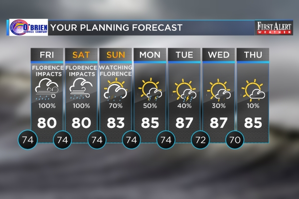
Florence made landfall near Wrightsville Beach at 7:15 a.m. Friday. The storm is now a tropical depression and should move northward away from the Carolinas in the coming days. In the not too distant future, a front will work in once Florence departs, bringing some much needed high pressure and by comparison, “good weather”.
MONDAY AND TUESDAY FORECAST DETAILS: Lingering scattered showers and storms will be possible as Florence, whether it be a tropical depression of remnant low, scoots toward the Ohio Valley. Clouds will vary, but temperatures will likely grow from the mid 70s to the mid 80s amid south breezes.
EXTENDED FORECAST: High pressure will move in by the middle of the week, which means plenty of sunshine and temperatures in the middle and upper 80s during the day, and 70s at night. This will no doubt aide crews working to restore services and clean up following the storm. Widespread lowland flooding will continue to be unavoidable; some spots that have never flooded will flood especially along rivers and estuaries. Read more about the record-setting river levels here.
National Weather Service-issued Flash Flood Warnings continue for all of southeastern North Carolina.
>> VISIT THE COMPREHENSIVE DIGITAL HURRICANE PREPAREDNESS CENTER <<
>> DOWNLOAD THE FREE WECT WEATHER APP NOW <<
ELSEWHERE IN THE TROPICS:Tropical Depression Joyce does not pose a threat to the Carolinas. Joyce will curve to the northeast out in the open Atlantic. There is also a broad area of low pressure, associated with the remnants of Issac, located near Jamaica in the central Caribbean Sea. The odds for any tropical development with this area will be low through midweek.
NEUWIRTH MOTORS FIRST ALERT SKY CAMERA NETWORK: CLICK HERE to enjoy views from the Battleship North Carolina, Wrightsville Beach, Surf City, Ocean Isle Beach, Southport, Whiteville, and Elizabethtown. (Note: cameras not available on mobile devices.)
Copyright 2018 WECT. All rights reserved.