- National memorial to honor NC firefighter who died on duty during Hurricane Helene
- Gov. Josh Stein extends State of Emergency for western NC wildfires
- Governor Stein extends state of emergency for NC wildfire threat
- Governor Stein extends emergency in 34 NC counties amid wildfire threat
- Texans can buy emergency preparation supplies tax-free April 26-28 ahead of severe weather season
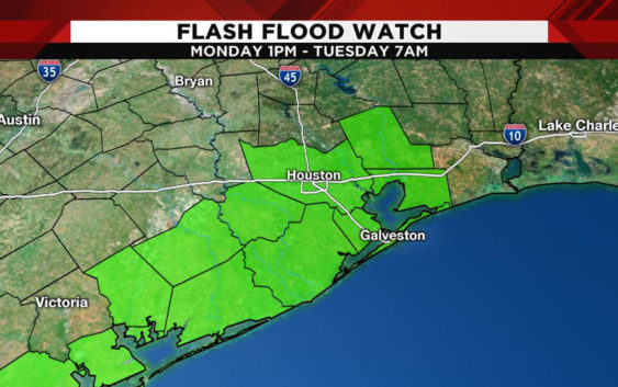
WEATHER ALERT: Flash flood watch issued for several southeast Texas counties


Forecasters warned of the possibility of heavy rain and flooding from Monday into Tuesday as a storm system moves through the region.
The National Weather Service issued a flash flood watch from 1 p.m. Monday until Tuesday morning for Brazoria, Chambers, Harris, Fort Bend, Galveston, Jackson, Liberty, Matagorda and Wharton counties.
Below is the official statement from the Weather Service:
…FLASH FLOOD WATCH IN EFFECT FROM 1 PM CDT THIS AFTERNOON
THROUGH TUESDAY MORNING…
The National Weather Service in Houston/Galveston has issued a
* Flash Flood Watch for portions of south central Texas and
southeast Texas…including the following counties…in south
central Texas…Coastal Jackson and Inland Jackson. In
southeast Texas…Brazoria Islands…Chambers…Coastal
Brazoria…Coastal Galveston…Coastal Harris…Coastal
Matagorda…Fort Bend…Galveston Island and Bolivar
Peninsula…Inland Brazoria…Inland Galveston…Inland
Harris…Inland Matagorda…Matagorda Islands…Northern
Liberty…Southern Liberty and Wharton.
* From 1 PM CDT this afternoon through Tuesday morning
* Thunderstorm activity may develop along the coast or just off
the coast this morning. Additional activity may begin to develop
this afternoon farther inland between the coast and Interstate
10. There may be a second round of thunderstorm activity to
develop overnight into Tuesday morning. The main concern with
these storms will be the rainfall rates and not so much the
total rainfall amounts for the event. Storms yesterday produced
rainfall rates of 2 inches an hour. Atmospheric conditions are
more favorable today into Tuesday to support these kinds of
rainfall rates if not more. This means that flash flooding could
occur if these rainrates persist for more than 1 to 2 hours
over the same area.
* The main impacts from these higher rain rates will be street
flooding in low lying and poor drainage areas. Rapid rises in
area creeks and bayous can be expected. Water levels should
remain within banks of bayous except if high rain rates persist
for longer than 2 to 3 hours.
PRECAUTIONARY/PREPAREDNESS ACTIONS…
A Flash Flood Watch means that conditions may develop that lead
to flash flooding. Flash flooding is a very dangerous situation.
You should monitor later forecasts and be prepared to take action
should Flash Flood Warnings be issued.
Copyright 2018 by KPRC Click2Houston – All rights reserved.