- Helene forced a North Carolina restaurant owner to leave his home. He just lost his 'Cabin of Hope' in recent wildfires
- Carolina wildfires grow, evacuation orders still in effect
- Helene forced a North Carolina restaurant owner to leave his home. He just lost his 'Cabin of Hope' in recent wildfires
- Severe weather likely in the Carolinas on Monday
- 3 dead, flash floods overwhelm South Texas, with some areas receiving more than 12 inches of rain
Brad Panovich Takes A Closer Look At Florence's Southerly Route

North Carolina Governor Roy Cooper is foreboding in his assessment Hurricane Florence.
“This storm is a monster. It’s big and vicious. It’s an extremely dangerous, life-threatening, historic hurricane.”
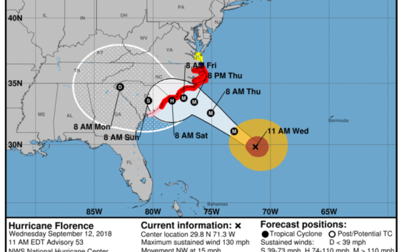
The path of Hurricane Florence has changed since Cooper made that statement Tuesday. The National Hurricane Center says it’s now expected to hit Wilmington and then veer west, taking it south of Charlotte.
WCNC-TV meteorologist Brad Panovich told WFAE Morning Edition host Marshall Terry that the shift of Florence means more rain for the Charlotte area.
Panovich: Well, it’s pretty interesting. This shift to the south certainly brings Charlotte into play for much heavier rainfall, and I think that’s going to be the biggest issue that we’re going to have to deal with in the Charlotte area is soaking heavy rains that could fall not only over a day but maybe several days after landfall. This would put us in a swath of maybe up to 4-8 inches of rain from Friday night to early Monday evening and could linger beyond that as the remnants cast off to our west. The other thing this will put us at increased threat for is for possible tornadoes. But one thing it might actually help is to reduce the overall wind speed, though we’re still going to have gusty winds around here which combined with that wet soil could bring down some trees.
Marshall: When should we now expect landfall along the coast?
Panovich: Right now it looks like landfall is going to occur sometime early Friday morning between, I would say, 4 a.m. and probably about 8 a.m., but it might actually never make it all the way in. That’s the interesting thing about this track, is that it stalls very near the coast. It could stall just off the coast and then drift south along the South Carolina coast and possibly make a landfall as a weaker system if it doesn’t make it clearly over the coast of North Carolina. So we could have two landfalls – one around Wilmington and then one near Myrtle Beach or even south of there. As it turns into southern South Carolina.
Marshall: Well, if it does follow the path of come more toward Charlotte, when can we expect to see the greatest effect here in the Charlotte region?
Panovich: The other interesting thing is in Charlotte our biggest impacts might be felt more Friday night into Saturday, and we will certainly see some wind on Friday but I think the rain may be kind of scattered about on Friday and the heavy stuff doesn’t really move in until Saturday. So we’re going to have delayed impacts from this even after landfall on Friday.
Marshall: You mentioned some hefty winds here in the Charlotte area. A lot of people hearing this are remembering Hurricane Hugo in 1989. I believe that was a Category 1 storm when it hit Charlotte. Will the winds be that strong or they’ll be stronger when they get here than that?
Panovich: They will be dramatically weaker. The thing about Hugo was it was coming from Charleston up to Charlotte and it was moving about 40 miles an hour. This system, when it gets to the coast, is only going to be moving about three miles per hour. So, the winds will be winding down much quicker near the coast before those winds get up here. So the winds here are actually going to be probably 30, maybe 35 miles per hour with some gusts to 40 which normally would not be a big deal but with the heavy rain, that causes trees to come down so we could still see trees and power outages from the much lower wind speeds.