- Seven months after Hurricane Helene, Chimney Rock rebuilds with resilience
- Wildfire in New Jersey Pine Barrens expected to grow before it’s contained, officials say
- Storm damage forces recovery efforts in Lancaster, Chester counties
- Evacuation orders lifted as fast-moving New Jersey wildfire burns
- Heartbreak for NC resident as wildfire reduces lifetime home to ashes
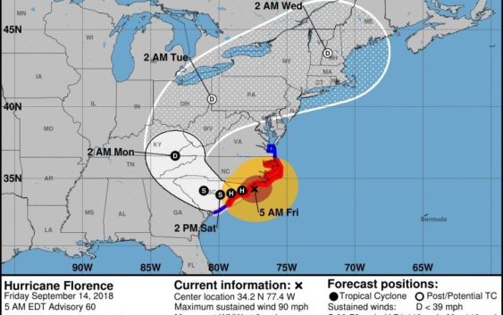
5 A.M. Update: Florence roars into Wilmington

Wind, storm surges and prolonged, heavy rain bring ‘life-threatening’ conditions to region
Wilmington should be ready for a prolonged and devastating impact as Hurricane Florence roars over Southeastern North Carolina on Friday.
“It’s probably going to take another 24 hours” for Florence to pass through the Wilmington region, Reid Hawkins, science officer with the National Weather Service office in Wilmington, said at 5 a.m. Friday.
The eye of Florence, a Category 1 hurricane with 90 mph sustained winds, was 25 miles east of Wilmington at 5 a.m. Friday, according to a briefing issued by the National Hurricane Center.
“The center of the eye will be moving across Pender (County) and Northern New Hanover in the next few hours,” Hawkins said.
The storm has already battered coastal areas with high winds as well as storm surges of more than 10 feet.
“The combination of a dangerous storm surge and the tide will cause normally dry areas near the coast to be flooded by rising waters moving inland from the shoreline,” the hurricane center advisory said.
>>READ MORE: Click here for complete coverage of Hurricane Florence.
But weather officials have cautioned that Florence’s promise of heavy rains — and the flash flooding and prolonged flooding it will cause — likely will be the storm’s most dangerous impact, especially since the storm surges will block the usual flow of water back to the ocean.
“This rainfall will produce catastrophic flash flooding and prolonged significant river flooding,” the National Hurricane Center briefing said.
Once it makes landfall, the storm is expected to stall, bringing record-shattering amounts of rain of up to 30 to 40 inches in some places. The three-day record for Wilmington is 19.66 inches set in 2010.
“The rainfall is going to be the big impact for the area,” Hawkins said.
And it won’t be a quick hit, as some rivers and waterways won’t immediately overflow, Hawkins said.
“Some of these flood waters won’t be realized for four or five days,” he said.