- Seven months after Hurricane Helene, Chimney Rock rebuilds with resilience
- Wildfire in New Jersey Pine Barrens expected to grow before it’s contained, officials say
- Storm damage forces recovery efforts in Lancaster, Chester counties
- Evacuation orders lifted as fast-moving New Jersey wildfire burns
- Heartbreak for NC resident as wildfire reduces lifetime home to ashes
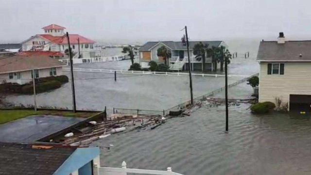
Across the state: Photos show shocking flooding in Emerald Isle
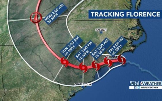
Hurricane Florence made landfall near Wrightsville Beach around 7:15 a.m. Friday as a Category 1 storm.
At a glance:
- Hurricane Florence made landfall near Wrightsville Beach around 7:15 a.m. Friday as a Category 1 storm.
- More than 500,000 customers are without power in North Carolina.
- 200 people have been rescued in New Bern and 150 are still awaiting rescue. New Bern is seeing the worst storm surge from Florence as flood waters are being pushed out of the Pamlico Sound.
- More than 12,000 people fleeing the storm have taken shelter at 126 shelters open across the state.
Latest updates
2:34 p.m.: A portion of Emerald Isle is, essentially, underwater. A viewer shared a photo of flooding in Salter Path near Willis Seafood.
“The town has recorded in excess of 11 inches of rain,” EI officials said in a press release. “Power is out everywhere, and it is likely to be several days before it is restored.”
In New Bern, crews have been rescuing people from flooded homes all day.
2:11 p.m.: Dozens of trees are down in Wilmington “as far as they eye can see.” Rainfall over the past several days has left the soil in Wilmington moist, contributing to the falling trees. Many of the trees that fell are large, old trees, and veteran hurricane reporter Amanda Lamb said the damage and wind gusts in Wilmington are some of the worst she has been in.
In Myrtle Beach, Bryan Mims is being pounded with rain as Hurricane Florence approaches the Grand Strand. Trees are down along King Highway, and the usually-packed tourist destination is a ghost town.
1:57 p.m.: Pictures of the Bogue Inlet Fishing Pier in Emerald Isle show chunks missing.
1:55 p.m.: The new number of outages statewide is more than 604,000.
1:18 p.m.: Winds have ripped the roof off of a mobile home in Clayton.
1:02 p.m.: A Kinston shelter has been evacuated due to power issues and safety concerns, according to police. People taking shelter are being transferred to Lenoir Community College.
12:40 p.m.: The statewide power outage now affects more than 557,000 customers.
12:20 p.m.: Less than 8 hours before the storm is expected to enter South Carolina, Myrtle Beach’s main tourist strip is deserted. The stoplights are out on Ocean Boulevard, and the road is empty.
12:09 p.m.: The studios of WCTI in New Bern are flooded. According to a reporter there, this is the first time the building has flooded since it was built in the 1950s.
12:06 p.m.: The wind and rain has started slowing in Wilmington as Florence moves toward South Carolina. Rain and winds will continue throughout the weekend.
12:04 p.m.: The Tar River may be out of the woods when it comes to flooding, Gardner said, as flooding is more of a concern to the south at this point. People who live near the Cape Fear River are asked to consider a voluntary evacuation.
11:42 a.m.: A tornado touched down in Bertie County at 10:30 a.m. Damages were reported but no injuries.
11:30 a.m.: The National Weather Service has issued a flood warning for the Cape Fear River with “confidence increasing in potentially catastrophic flooding in the Sandhills and the southern Coastal Plain.” A voluntary evacuation is recommended to people who live in close proximity to the river.
11:21 a.m.: South Carolina is beginning to feel the impact of Florence. Elizabeth Gardner said Florence could be in Myrtle Beach by 8 p.m.
11 a.m.: “To those in the storm’s path, if you can hear me, please stay sheltered. Do not go out in this storm,” said Gov. Roy Cooper during a briefing on Hurricane Florence.
The governor also stated that the Lumber and Cape Fear rivers are expected to crest even higher than they did following Hurricane Matthew in 2016.
“Remember, rivers will keep rising for days even if the rain stops,” he said. “Pay attention to evacuations and leave if you are told to.”
10:45 a.m.: Streets in New Bern are impassable due to downed trees. On one street, the Neuse River could be seen overflowing onto the street.
10:27 a.m.: A crew from the National Guard is rescuing a family from a flooded home in New Bern.
10:23 a.m.: Atlantic Beach and Morehead City are seeing significant flooding and damage to buildings.
10:08 a.m.: Winds recorded at 105 mph at the Wilmington airport are the strongest winds ever on record. Wilmington and Brunswick County communities like Bolivia and Oak Island have seen rainfall up to 8 inches.
9:56 a.m.: The Outer Banks is relatively calm Friday morning as Florence targets other areas. A resident in Carteret County posted photos of significant flooding on Facebook.
9:16 a.m.: The popular Bogue Inlet Pier in Emerald Isle has suffered some damage.
8:04 a.m.: The statewide power outage has jumped to 403,000.
7:58 a.m.: WECT tweeted a photo of a gas station that was severely damaged in Wilmington.
7:39 a.m.: Closer to home, the Tar River in Greenville is close to flooding. Officials say the flood stage for the river is 13 feet, and it is currently past 9 feet and rising steadily. Tranters Creek near Washington, North Carolina is experiencing minor flooding, and the town is suffering as a result.
7:26 a.m.: Wilmington is experiencing its highest wind speeds since 1960. That’s greater than Floyd and Fran.
7:15 a.m.: The storm officially made landfall in Wilmington at 7:15 a.m.
6:54 a.m.: Storm surge (the rising of the sea) in Wilmington is up to 3 feet, but major flooding has not yet been reported there. New Bern is experiencing some of the worst flooding due to overflow from the Pamlico River. The eyewall of the storm is spinning on the coast near Topsail Island, but the National Hurricane Center has not confirmed that center of the eye has made landfall.
6:32 a.m.: The statewide power outage is now at more than 340,000. Crews from Greenville are traveling to New Bern to assist crews with more than 100 rescues.
6:10 a.m.: Wilmington will deal with the storm’s eyewall for several hours as the storm slowly moves onshore. Amanda Lamb is in Wilmington and reported that large pieces of sheet metal were flying through the air and car alarms were sounding. Wilmington is currently experiencing winds at 85 mph. The top winds from the storm were recorded at 106 mph in Cape Lookout.
5:55 a.m.: Hurricane Florence is expected to make landfall near Topsail Beach.
5:53 a.m.: A household in New Bern has tweeted that they need help. They are stuck in their attic and their home is flooded. They are among dozens waiting on crews.
5:44 a.m.: Officials in New Bern said crews have been working to rescue at least 200 people overnight. There are about 150 people waiting to be rescued.
5:23 a.m.: About 70 occupants have been evacuated from a hotel in Jacksonville, North Carolina after hurricane force winds threatened the structural integrity of the building. The group, which included an infant, children and pets, have been taken to the Jacksonville Center for Public Safety after portions of the roof collapsed. No one was injured.
5:16 a.m.: The Outer Banks is now in better shape, but Wilmington is being pounded with rain and winds as the center of the storm gets closer to making landfall.
5:09 a.m.: WRAL reporter Amanda Lamb was barely able to keep her balance in Wilmington while standing outside in 70 mph winds.
5 a.m.: The latest update from the National Hurricane Center shows little change to Florence’s path or strength. The Category 1 storm has maximum sustained winds of 90 mph and is moving slowly, at 6 mph.
4:37 a.m.: A whopping 280,000 customers are without power in North Carolina. The highest numbers are being reported in New Hanover County.
4:13 a.m.: We will get an updated look at Florence’s projected path at 5 a.m.
4 a.m.: Twenty-eight roads are closed in New Hanover County due to flooding, and power outages are widespread. In Craven County, New Bern’s mayor says the town has seen historic flooding, with as much as 10 feet of water reported in some places. Highway 12 is still closed in Dare County. The road closed Thursday afternoon when it flooded 15 hours before Florence was expected to make landfall.
