- Seven months after Hurricane Helene, Chimney Rock rebuilds with resilience
- Wildfire in New Jersey Pine Barrens expected to grow before it’s contained, officials say
- Storm damage forces recovery efforts in Lancaster, Chester counties
- Evacuation orders lifted as fast-moving New Jersey wildfire burns
- Heartbreak for NC resident as wildfire reduces lifetime home to ashes
Hurricane Florence: Search map of potentially deadly Mecklenburg County dams

As Hurricane Florence rumbled across the Atlantic Ocean last week, a group of North Carolina officials left an annual dam safety conference in Seattle to begin monitoring the roughly 5,700 dams across the state.
They reached out to dam owners, asking that they check the integrity of their structures and lower water levels if need be.
Now a group of state dam safety officials are huddled in the emergency operation center in Raleigh. They’re in contact with state and local emergency operators, said Bridget Munger, spokeswoman for the N.C. Department of Environmental Quality.
“Any time we have severe weather, there are concerns,” Munger said, “especially when we’re looking at what could be record-breaking rainfall.”
Hurricane Florence is expected to dump up to two feet of rain onto parts of North Carolina and about 10 to 15 inches in the Charlotte area.
That can topple dams.
About 50 dams failed in South Carolina after a 2015 storm dumped two feet of rain. They breached about 20 more in South Carolina when Hurricane Matthew hit a year later.
North Carolina is home to more than 1,400 high hazard dams — dams that could kill people if they fail. Seventy-nine are in Mecklenburg County.
Despite their importance, many high hazard dams go unnoticed, often made of earth and tucked in small residential neighborhoods.
For example, eight high-hazard dams are located in or near Piper Glen Estates by Interstate 485 in south Charlotte.
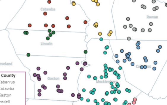
Use the map below to see all high hazard dams in Mecklenburg and its surrounding counties.