- NC burn ban lifted statewide as rain improves wildfire conditions
- Western NC wildfire risk will 'get worse, not better' Ag Commissioner says, pressing lawmakers for help
- Watering trees is a must to protect them from severe weather and drought
- At least 4 dead, hundreds rescued after deadly floods ravage South Texas
- Today on Texas Standard: Deadly floods swamp South Texas, shatter records
Richland, Lexington counties issued storm watches as hurricane closes in on landfall

The 11 p.m. update on Hurricane Florence has placed most Midlands counties under a storm watch or warning, including Richland and Lexington counties, according to the National Weather Service in Columbia.
Both a tropical storm watch and a flash flood watch have been issued for Richland County and Lexington County, among many others in the area.
That’s because Hurricane Florence, now a Category 1 storm with 90 mph winds, is expected to move very slowly west Friday toward South Carolina.
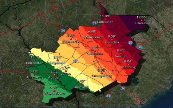
Based on the current track of Hurricane Florence, the central Midlands are expected to get 3-6 inches of rainfall, and 25 to 35 mph winds with gusts up to 45 mph, according to NWS Columbia.
The tropical storm force, or strong winds are expected in the central Midlands Friday night or Saturday morning, and will slowly reduce through Sunday, NWS Columbia reported, adding “this will likely be a long duration event (Friday through Sunday).”
NWS Columbia reported that confidence is high that the Midlands will experience areas of flooding because of the heavy rainfall.
Isolated tornadoes will be possible in the northern Midlands and Pee Dee area, which are expected to get between 5-10 inches of rain, with isolated amounts of 15-plus inches near the North Carolina border. The winds
“The strong wind gusts may down trees and power lines. The heavy rainfall will increase the risk of trees uprooting and toppling,” according to a NWS Columbia news release. “The strong winds will also blow around any loose objects, lawn furniture and trash cans.”
The heavy rainfall will “produce flash flooding and river flooding across the Midlands,” and even though weather conditions are expected to improve Monday, “flooding on the area rivers will increase as the runoff from heavy rains moves through the river basins,” per NWS Columbia.
NWS meteorologist Jeff Linton warned that water traveling from North Carolina and northern regions of the state will make its way into the Columbia area. The increase in water volume should be expected Monday or Tuesday.
NWS Columbia reported that there is the possibility for more changes in the track and intensity in the coming days.
“The worst conditions across central South Carolina … are expected Friday night into at least Sunday, although impacts could linger longer depending on the uncertain evolution and track of Florence beyond this weekend,” the National Weather Service said.
Tropical Storm Warning
▪ Chesterfield County
▪ Lee County
▪ Sumter County
▪ Clarendon County
▪ Calhoun County
▪ Orangeburg County
Tropical Storm Warning
▪ Lancaster County
▪ Kershaw County
▪ Fairfield County
▪ Richland County
▪ Lexington County
Flash Flood Watch
▪ Lancaster County
▪ Chesterfield County
▪ Newberry County
▪ Fairfield County
▪ Kershaw County
▪ Saluda County
▪ Lexington County
▪ Richland County
▪ Lee County
▪ Sumter County
▪ Orangeburg County
▪ Clarendon County
▪ Calhoun County