- Report: Coastal flooding could threaten 1.4 million homes by midcentury
- Caught on camera | Tornado touches down in Missouri
- Carolina Hurricanes playoff tickets go on sale next week
- Storms kill 6 in the South and Midwest as forecasters warn of catastrophic rains, floods this week
- Weather Impact Alert: Cold front could trigger severe weather in Houston area this weekend | See timeline
The latest: Category 1 Florence could still have 'devastating' impacts in parts of NC

Raleigh, N.C. — Although Hurricane Florence has not yet made landfall, the storm is already pounding North Carolina’s coast with devastating winds and rain. The hurricane has slowed and should make landfall near Wilmington around 8 a.m., with most of the state feeling its effects throughout the weekend.
Latest updates
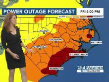
1:16 a.m.: North Carolina officials are reporting that 169,411 customers are currently without power across North Carolina with the majority of outages reported in the eastern part of the state.
1:08 a.m.: WRAL Chief Meteorologist Greg Fishel said the Neuse River is reporting 10.1 feet of inundation as a result of Florence, which is still moving northwest at about 6 mph.
The storm, which currently has sustained winds of 85 mph, is expected to make landfall sometime between 6 a.m. and noon Friday.
The storm is expected to weaken into a tropical storm by Friday evening, Fishel said, and will have minimal impacts in the Triangle, but could have devastating impacts toward the southern part of the state, including Cumberland County.
12:45 a.m.: Officials said 55 people have reported to seven emergency shelters in Cumberland County and residents are advised to bring sleeping bags, blankets and cots as some shelters have a limited number of beds.
Swift water rescue teams are ready in Cumberland County to assist with rescues if necessary and the Fayetteville Fire and Emergency Management Department has seven swift water teams on hand.
12:27 a.m.: Florence is 40 miles from Wilmington and 30 miles from Moorehead City and is continuing to move at 6 mph
WRAL meteorologist Mike Maze said it is possible that there could be brief, isolated tornadoes as a result of the storm.
12:13 a.m.: Topsail Beach Town Manager Mike Rose said officials are monitoring the storm surge, which remains the biggest concern as Hurricane Florence prepares to make landfall.
“We’re certainly concerned about the rain and the flooding that will come but, right now, our biggest concern is the storm surge itself,” Rose said.
Rose said emergency services have been suspended until conditions on the island improve, but officials are working with multiple agencies to return to the island when conditions allow.
“We feel confident we’ll be in good shape,” Rose said.
Rose said that there are only 400 residents who live on Topsail Beach year round and they were able to evacuate in advance of the storm.
“We’re fortunate that this has come at a time where most of the tourism has gone,” he said.
12:06 a.m.: Wilmington is experiencing periods of severe weather followed by periods of calm as rain bands associated with Florence move through. Although weather is currently calm, the storm caused transformers to blow and telephone poles to sway in the wind earlier in the night.
12:04 a.m.: WRAL meteorologist Mike Maze said that Florence is continuing to move northwest at 6 mph is is expected to make landfall at about 8 a.m.
12:01 a.m.: Camp Jejeune has been experiencing widespread power outages across the base for several hours as a result of Hurricane Florence. A spokesman said there are several buildings that have been operating on generator power, but the base is largely in the dark.
Thursday updates:
11:39 p.m.: A 10 foot storm surge has been reported in Moorehead City.
The center of the storm is currently located less than 50 miles from Wilmington and 118 miles from Fayetteville.
11:09 p.m.: North Carolina Emergency Management said 156,068 customers are without power in the state as a result of Hurricane Florence. The highest number of outages have been reported in Beaufort, Carteret, Craven, Onslow, Pamlico and Pender counties.
11:04 p.m.: Although Florence will now make landfall as a Category 1 hurricane, the storm still has the potential to bring substantial rain and dangerous flooding to the state.
WRAL Chief Meteorologist Greg Fishel said that the worst case scenario models show Wake, Durham and Orange counties getting 5-10 inches of rain while counties to the south could get 10 to 15 inches. Counties in the far south, including Cumberland County, could see as much as 20 inches of rain through Sunday.
11:02 p.m.: Officials said more than 136,000 people are without power in North Carolina, largely in the eastern part of the state.
11 p.m.: The 11 p.m. update from the National Hurricane Center show that Hurricane Florence is weakening.
The storm, which has sustained winds of 90 mph and is moving northwest at 6 mph, will not make landfall Friday morning as a Category 1 storm.
“Hopefully that will continue to be a trend,” WRAL meteorologist Mike Maze said of the storms weakening wind speeds and increasing speed, which both bode well for North Carolina.
The storm is 60 miles from Wilmington.
10:53 p.m.: Flood water was rushing into the Craven County Emergency Services building Thursday night as areas around the county experienced severe flooding. Officials said there was a drain pressure that caused water to enter the building, but nobody inside was injured.
10:52 p.m.: Shelters were open and about 100 people had registered to stay at Northwood High School and Chatham Middle School in Chatham County.
10:11 p.m.: Stephen Rea, with Carteret County Emergency Management said he is hearing reports of damage throughout the whole county.
10:05 p.m.: Florence is located about 70 miles southeast of Wilmington and continues to have sustained winds of 100 mph.
The hurricane is expected to make landfall sometime between 6 a.m. and noon Friday.
9:51 p.m.: Portions of Atlantic Beach have already reported more than a foot of rain and Cherry Branch in Craven County has reported a storm surge of more than 10 feet, WRAL Chief Meteorologist Greg Fishel said.
9:42 p.m.: Nags Head is experiencing a calm in the storm, with rain stopping for more than an hour and counting. WRAL meteorologist Mike Maze said the worst of the storm may be over in that part of the Outer Banks.
9:20 p.m.: North Carolina Emergency Management said 102,308 customers were without power as of 9 p.m. Thursday as a result of Hurricane Florence. The counties with the most outages reported are Beaufort, Carteret, Craven, Onslow and Pamlico.
9:06 p.m.: Hyde County officials have issued a curfew, effective from 9 p.m. to 5 a.m. until further notice.
9:02 p.m.: Cape Lookout National Seashore has reported sustained winds of 83 mph with gusts of 106 mph while Fort Macon State Park has reported sustained winds of 70 mph with gusts of 105.
In Oriental, the water height in the Neuse River was recorded at 5.5 feet above normal, according to WRAL Chief Meteorologist Greg Fishel.
Florence continues to move towards the North Carolina coast at 5 mph with winds of 100 mph, but any changes to the storm’s path won’t be known until the National Hurricane Centers issues the next advisory at 11 p.m.
8:54 p.m.: The Hope Mills Dam, which has been prone to flooding in the past, appeared to be holding up as the storm moves in.
8:50 p.m.: Colleen Roberts, a public information officer with the City of New Bern, said the storm has taken an “chaotic turn” in the city.
Roberts said officials said the storm surge was already estimated at about 7.5 feet and is expected to grow as the storm makes landfall.
Much of downtown New Bern was underwater by Thursday night and Roberts said several families had to be reduced from their homes.
“If you need emergency rescue, of course we were going to come out and get you, but this is one of the reasons Craven County issued an emergency evacuation,” she said.
Roberts said that emergency services were suspended just before 8 p.m. because conditions were becoming unsafe for first responders.
8:45 p.m.: The tornado warning has been canceled for Wilson County.
8:40 p.m.: WRAL meteorologist Mike Maze said that there will likely be more tornado warnings issued Friday, but no tornado has touched down amid the warning in Wilson County.
8:38 p.m.: WRAL meteorologist Mike Maze said tornado warnings are not uncommon when an hurricane makes landfall or approaches land. A tornado warning was issued earlier Thursday for Carteret County.
8:36 p.m.: The tornado warning remains in effect for Wilson County until about 9 p.m. The storm is located 7 miles away from Wilson and Farmville and is moving southwest at 35 mph.
8:34 p.m.: A tornado warning has been issued for Wilson County
8:31 p.m.:Gov. Roy Cooper said officials are working to set up more shelters as they anticipate more evacuations will be necessary once rivers rise and flooding sets in.
“I believe we have a great team in place, swift water rescue teams ready, lots of supplies ready to go to these shelters,” Cooper said. “I ask people to hunker down, stay off roads. We can get through this, have to endure a tough couple of days.”
8:12 p.m.: Although Hurricane Florence continues to get closer to the coast, several coastal areas including Wilmington and Nags Head were experiencing lulls in rainfall as rain bands moved through.
8:09 p.m.: Hurricane Florence remains 85 miles off the coast near Wilmington, but with storm surges of 6 feet already being reported, WRAL meteorologist Mike Maze said there is potential for the storm surge to exceed to 7 to 11 foot estimate once the hurricane makes landfall.
Florence is still expected to make landfall Friday morning, but Maze said the slow-moving storm could reach land later than originally anticipated.
“The way it’s moving now, it may not get there until late in the morning,” he said.
8:02 p.m.: A curfew will be in place for all Spring Lake residents from 10 p.m. to 7 a.m. as Hurricane Florence approaches, according to Mayor Larry Dobbins.
7:43 p.m.: WRAL meteorologist Kat Campbell, who used to work at WCTI, said the area is very prone to flooding and floods are currently impacting much of New Bern.
Campbell said that the flooding the area was experiencing Thursday night was already exceeding what they saw during Hurricane Matthew in 2016.
All employees, with the exception of two meteorologists, have left the WCTI news station because of the floods.
“Everyone was asked to leave immediately, we have stayed here to keep everyone up to date,” one of the meteorologists said during a live news broadcast. “We have a situation that has developed here at the station. We have water close to the building. The building has been evacuated.”
7:31: Hurricane Florence is now 85 miles southeast of Wilmington.
As the storm approaches, more than 88,000 people in North Carolina are without power with the highest number of outages reported in Beaufort, Carteret, Craven, New Hanover, Onslow and Pamlico counties.
7:29 p.m.: Employees at WCTI, an ABC-affiliated news station in New Bern, were evacuating Thursday night as flooding became an issue throughout the area.
A spokesperson for the station said that roads around the building were beginning to flood and a skeleton crew would remain in place to provide news coverage of the storm to residents.
7:24 p.m.: As weather conditions worsen, Carteret County Emergency Services have been suspended until wind speeds once again reach a save level.
7:11 p.m. In New Bern, flood waters were already starting to overtake vehicles, submerging them in water in parking lots.
7:09 p.m.: WRAL meteorologist Mike Maze said Hurricane Florence won’t move out of the United States until Tuesday.
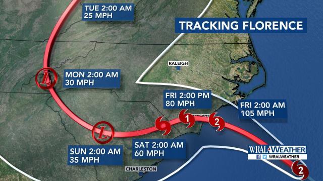
By Saturday, the system should be downgraded to a tropical storm, but rainfall will continue to be heavy, Maze said. The system is expected to make landfall Friday morning and move into South Carolina on Saturday. The storm will then curve into the Appalachians, where the terrain could lead to major flooding.
“We probably won’t see a good deal of sunshine until we get into Wednesday of next week,” Maze said.
7:05 p.m.: State officials said that more than 12,000 evacuees have taken shelter at 126 shelters open across the state. State emergency management officials are working to set up additional shelters, according to the Governor’s Office.
Utility companies have reported that more than 79,000 people in North Carolina were without power by 6:30 p.m.
6:48 p.m. WRAL Chief Meteorologist Greg Fishel said one of the benefits of Florence’s slow movement is that the storm will have time to mix with cooler water, which could lead to weakening. The slow speed, however, will also result in devastating storm surge and flooding.
“The slow movement is going to mean many, many hours of surge issues and relentless rain,” he said.
6:43 p.m.:Agriculture Commissioner Steve Troxler said the advanced warning about Florence and the State of Emergency that allowed farmers to get crops out of the field early have been beneficial, but it’s too soon to know what impact the storm will have on supplies and prices.
“This is payday for farmers. This is when you get all the crops in and get paid for all the work you put in, but this is an act of God, you can’t change it,” he said.
6:38 p.m.: Hyde County officials said EMS operations have been suspended until further notice as a result of deteriorating weather conditions.
According to officials at Raleigh-Durham International Airport, Air Canada, Alaska Airlines, Frontier and Southwest have canceled all flights for Friday. American Airlines said they will offer a few flights early Friday morning before suspending service through Saturday. United Airlines and JetBlue will operate limited flights Friday and Delta will operate a near normal schedule.
6:34 p.m.: Florence is 90 miles away from Wilmington and moving at 5 mph. Forecast models show the storm will still be offshore as of 2 a.m. Friday and will make landfall as a Category 1 storm sometime Friday morning or afternoon.
6:21 p.m.: Gov. Roy Cooper said the number of people in shelters is increasing, but there are some areas where evacuation may no longer be safe.
“Obviously, if you’re in an evacuation area, we want you gone, but we don’t want you to drive through water,” Cooper said.
Cooper said he wants people to stay safe, get their emergency kits prepared and help each other during the storm.
“We’ve got a lot of work ahead. We’re going to have to work together, we’re going to have to work patiently, but I believe in the people of North Carolina,” he said.
6:03 p.m.: Hurricane Florence’s winds have increased slightly, to 105 mph, and the storm is located about 95 miles southeast of Wilmington.
Cape Lookout National Seashore has reported sustained winds of 68 mph and wind gusts of 84 mph.
Florence is still expected to make landfall Friday but the slow-moving storm will still be just west of Wilmington by about 2 p.m. Friday.
“This is going to be an incredibly long duration event,” WRAL Chief Meteorologist Greg Fishel said.
5:48 p.m.: More than 68,800 people are now without power in North Carolina including 23,229 in Carteret County, 2,625 in Craven County, 2,323 in New Hanover County, 2,243 in Onslow County and 2,649 in Pamlico County.
5:26 p.m.: WRAL Chief Meteorologist Greg Fishel said that the size of Florence makes it as powerful as a stronger hurricane that is more intense.
It is for this reason that the tropical storm warning has been extended to Wake County. The area could see sustained winds of 39 mph, but the strong winds won’t start until Friday.
“We’re still not anticipating the kinds of winds here in Raleigh that we had with Fran,” Fishel said.
5:24 p.m.: About 100 residents from a Fayetteville assisted living facility evacuated to a nearby hotel as a precaution as Florence approaches. Parts of Cumberland County experienced devastating flooding when Hurricane Matthew moved through in 2016.
5:19 p.m.: The National Weather Services has extended a flood watch to several counties including Johnston, Edgecombe, Orange, Durham, Wake, Cumberland and Nash. The flood watch will remain in effect until 8 p.m. on Sept. 16.
5:16 p.m.: Officials said 378 people have signed in to seven Cumberland County shelters and residents in low-lying and flood prone areas are urged to seek shelter.
5:08 p.m.: During a press conference, Gov. Roy Cooper said that the power outages and severe weather conditions being experienced Thursday are just a taste of what is to come when the worst of the storm begins after Florence makes landfall.
“Surviving this storm will be a test of endurance, team work, common sense and patience,” he said.
Cooper warned that more flooding will be possible as Florence makes landfall. A northern portion of the Cape Fear River was already flooding Thursday and the Neuse River was rising, he said.
“Remember, rivers keep on rising even after the rain stops,” Cooper said.
Cooper thanked those who evacuated before Florence approached and warned those who remained to seek shelter before it is too late.
“To anyone still unwilling to take this storm seriously, let me be clear, you need to get yourself to a safe place now and stay there,” he said.
5:03 p.m.: WRAL Chief Meteorologist Greg Fishel said there is a chance Florence could intensify slightly tonight, but the storm will likely weaken to a Category 1 hurricane by time it makes landfall during the late morning or early afternoon hours on Friday.
The storm surge along the coast will continue to get worse as Florence approaches and Fishel said the slow-moving storm will still be in South Carolina by 2 p.m. Saturday, producing heavy rain for the southern North Carolina counties as well.
4:56 p.m.: Power outages in North Carolina are climbing rapidly with more than 27,000 outages reported.In Carteret County, more than 17,600 customers are without power.
4:55 p.m.: A tropical storm warning has been extended to include parts of the Triangle, including Wake County including Raleigh, Cary and Wake Forest. Cumberland, Edgecombe, Harnett, Hoke, Johnston, Lee, Moore, Richmond, Scotland and Wilson counties are also under a tropical storm warning until further notice.
4:50 p.m.: Duke Energy is reporting that more than 15,600 customers are without power in North Carolina with the largest number of outages, 6,814, reported in Carteret County.
4:45 p.m: The 5 p.m. update from the National Hurricane Center shows that Florence’s wind speeds have decreased to 100 mph, but the storm is still expected to make landfall as a Category 2 hurricane.
The slow-moving storm is expected to make landfall sometime late Friday morning and is approaching the coast at 5 mph
“Really, over the next 22 hours, it’s not going to move all that much,” Fishel said.
Florence will be a tropical storm by 2 a.m. Saturday, which is expected to cross into South Carolina. By 2 p.m. Saturday, the storm is still expected to remain over the state, dumping inches of rain.
4:25 p.m.: Lee County has declared a State of Emergency and will impose a county-wide curfew that will begin at 9 p.m. The curfew will remain in effect until further notice, officials said.
4:20 p.m.: Florence remains a Category 2 hurricane and sits about 158 miles from Nags Head and 78 miles from Atlantic Beach. The storm is continuing to slow down, currently moving at 5 mph, and is still on track to make landfall at about 8 a.m. Friday.
“The forecast for this slowing down has been emphatic and it is happening right on schedule. That is not good news,” WRAL Chief Meteorologist Greg Fishel said.
Models show that Florence will still not have crossed into South Carolina by 8 p.m. Friday, meaning the North Carolina coast and southern counties will see significant rainfall from the slow-moving storm.
“As a result of that, these areas are going to be pelted with relentless rain and wind for an extended period of time and the chances for devastation are very real,” Fishel said.
By Sunday night, southern counties could see more than 20 inches of rain, Fishel said. Areas like Lee, Harnett and Wayne counties could see between 10-15 inches. The southern part of Wake County could see 7 to 10 inches of rain and the northern part of the county could see 5 to 7 inches.
“We may not be completely done with this until sometime Sunday night or Monday, depending on how this thing curves,” Fishel said.
4:08 p.m.: The North Carolina Electric Cooperatives report that about 11,000 members were without power Thursday afternoon. More than 7,000 of those outages are located in Carteret County, 1,500 in Craven County and 1,000 in Pamlico County.
The primary cause fo the power outages is high winds and soggy ground that has caused trees to fall on power lines.
Duke Energy is reporting more than 12,600 customers were without power in North and South Carolina.
4:02 p.m.: In anticipation of historic damage across the state, Gov. Roy Cooper has requested a presidential disaster declaration to speed up the process of receiving federal aid for cleanup and recovery.
“We know this massive storm will cause incredible damage and I’m asking Washington to act quickly so federal recovery help can come as soon as possible,” Cooper said in a statement.
The new declaration would provide federal help with debris removal, FEMA search and rescue teams, medical teams, hazardous material cleanup assistance, meals, generators and fuel.
3:39 p.m.: A business owner in Raleigh has built an earth structure around his building on Durham Drive to protect it from flooding. He says the area has flooded for years and took matters into his own hands despite contacting the city.
3:23 p.m.: At Crabtree Valley Mall in Raleigh, crews are already preparing for the parking deck to flood with water from Crabtree Creek. Since the deck has flooded before during both hurricanes and storms, crews used caution tape and orange cones to block off the flood prone area of the busy mall.
3:18 p.m.: The Neuse River has overflowed, flooding downtown New Bern, and video showed people walking through the streets with water close to their knees.
3:08 p.m.: Mike Maze reminded us that Hurricane Matthew was incredibly devastating to communities although it never made landfall in North Carolina. Those same communities are at risk again this week. Matthew brought rain totals of 14.1 inches to Fayetteville, and 15 inches are expected from Florence this week.
3 p.m.: Goldsboro could see winds as strong as 50 mph by 6 p.m., while New Bern could see 90 mph winds. Winds in Raleigh were recorded at 14 mph Thursday afternoon, and that number could increase to 45 mph by 6 p.m.
“You will hear the howling of the storm while you’re trying to sleep tonight,” said WRAL meteorologist Mike Maze.
The winds will start to die down in the Triangle Saturday as the storm passes.
2:45 p.m: In Morehead City, WRAL reporter Candace Sweat had to hold on to her hat during a live report. Carteret County is one of the areas most affected in the statewide power outage, which is now close to 17,000.
2:41 p.m.: Rain bands should start moving into the Triangle in the next few hours. Isolated tornadoes are a risk for the Triangle and areas to its east for the rest of Thursday as rain bands pass through. Wake County is not yet under a tornado watch, but one is likely.
2:15 p.m.: An old Kmart parking lot in Garner has become a staging area for the state’s emergency fuel crew. These trucks will be used to refill fuel in emergency vehicles during the hurricane. Some of the crew members traveled from as far as California to assist. Cary Towne Center is also a staging site.
1:55 p.m.: The updated statewide power outage is 12,146, mainly in Craven and Carteret counties, according to N.C. Emergency Management.
1:42 p.m.: Topsail Beach announced they would cut off their water at 2 p.m.
1:37 p.m.: Hurricanes move more slowly when they reach land because they have to pass over structures, trees and more. For this reason, Hurricane Florence will be devastating when it makes landfall in the southeast.
1:30 p.m.: Hurricane Florence is 240 miles from Raleigh and 130 miles from Wilmington. Instead of overnight, as originally predicted, the storm should make landfall around 8 a.m.
1:20 p.m.: The Hunt Horse Complex at the State Fairgrounds in Raleigh is opening as an equine evacuation site until it is safe for evacuated horses to return to their farms or until Sept. 24, when the building closes for the State Fair Horse Shows.
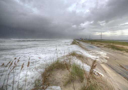
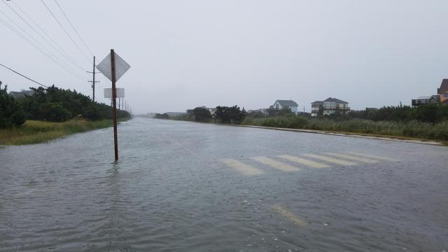
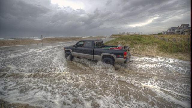
1:10 p.m.: N.C. Highway 12 is closed in both directions between the Bonner Bridge and Hatteras Village due to ocean overwash.
1 p.m.: Wake County will open additional emergency shelters today at Heritage High School in Wake Forest, Middle Creek High School in Apex and Sanderson High School in Raleigh. The shelters open at 1 p.m., 2:30 p.m. and 4 p.m., respectively.
12:45 p.m.: More than 5,000 people are already without power in North Carolina 12 hours before Hurricane Florence is expected to make landfall. The majority of those affected are in Carteret, Columbus, Craven and Brunswick counties.
12:25 p.m.: Morehead City and Atlantic Beach are some of the first to witness the dangerous strength of Florence. A shaking weather cam showed crashing waves and strong winds beating against a wooden pier. In the Outer Banks, photos show water washing onto shore before the storm even makes landfall.
12:15 p.m.: Duke Energy confirmed that it has shut down its nuclear plant in Brunswick County. The county, located in the southeast corner of the state, is one of the areas expected to be hit the hardest.
12 p.m.: Overwash has already been reported on N.C. Highway 12 north of Rodanthe. In one hour, more than inch of rain fell in Carteret County, where a tornado warning was reported earlier today. Meanwhile, the state’s central counties are also bracing for the storm.
11:30 a.m.: Tornado warnings have been issued in Carteret and Hyde counties.
11:05 a.m.: The Triangle will likely see some rain at lunchtime and scattered storms shortly after. More severe weather, like stronger winds and heavy rain, will start overnight and carry us into Friday morning.
11 a.m.: The latest update from the National Hurricane Center shows little change to the path of Hurricane Florence. The storm’s maximum sustained winds have weakened slightly from 110 to 105 mph, but it still remains Category 2 and dangerous. Strong wind and rains have already started at the coast.
10:30 a.m.: Peak Lab Rescue in Apex is working to limit the number of shelter dogs euthanized ahead of Hurricane Florence. When staff at animal shelters in communities with mandatory evacuations have to leave, there is no one left the care for animals. The Apex rescue group has removed more than 25 dogs from shelters in Lenoir and Columbus County ahead of the hurricane to minimize loss of life.
10:18 a.m.: Video and photos from the entire coast, including the Outer Banks and Wilmington, are already showing strong wind from Florence. The storm is estimated to make landfall just after midnight.
10:15 a.m.: WakeMed has partnered with a hospital near Florence’s projected landfall to bring NICU infants from Wilmington to Raleigh.
10 a.m.: Gov. Roy Cooper echoed FEMA’s message in a press conference about North Carolina’s preparations, stating he is worried that some people have said North Carolina is in the clear. Devastating storm surge is expected at the coast, and Elizabeth Gardner said the effects of Florence, which is several hundred miles wide, will be felt into Virginia.
“My message today — don’t relax. Don’t get complacent. This is the type of storm that can kill you. Today the threat becomes a reality. Get to a safe place and stay there if you haven’t already,” said Gov. Cooper. “Make no mistake. Whether the eye of the storm makes landfall along our shores or farther south, we’re on the wrong side of this thing. This storm will bring destruction to North Carolina.”
Gov. Cooper also reminded listeners that Matthew didn’t make landfall, but it was catastrophic for the state.
9:30 a.m.: FEMA officials said the southeast portion of North Carolina could get 30 to 40 inches of rain. Officials can not stress enough the severity of the storm, especially in terms of storm surge.
9 a.m.: “Please do not let your guard down,” said FEMA’s administrator during a Hurricane Florence briefing in Washington, D.C, referencing that even though the storm is now Category 2 the storm surge and rainfall estimated have not changed. “Your time [to evacuate] is running out.”
8:10 a.m.: The Storm Prediction Center has issued a tornado watch for the eastern coastal plain and central coast for the remainder of the day. Tornadoes associated with tropical systems tend to be brief, fairly weak and fast moving, but nonetheless can produce some enhanced localized damage. If any form today, they will tend to move toward the south or southwest.
7:55 a.m.: According to Elizabeth Gardner, we might see some scattered showers starting after lunch today and some storms this evening. Strong winds from the hurricane won’t be felt until late Thursday and overnight.
7:25 a.m.: The Raleigh-Durham International Airport has tweeted that there are approximately 120 cancelations (55 arrivals and 65 departures) out of 400 daily flights.
7:10 a.m.: In Dare County, winds are picking up just like they are in Wilmington. Despite mandatory evacuation orders for the Outer Banks, a group of seasoned locals told WRAL they would remain at their homes and that they’ve been through this before. Even though the path of the storm has shifted significantly south, toward Wilmington and Brunswick County, officials in the Outer Banks are concerned about storm surge and flooding.
6:50 a.m.: Curious to know if your home is at risk for flooding? The City of Raleigh has an interactive map to help you find out.
6:30 a.m.: The bridge that leads to Wrightsville Beach is closed, and officials say they evacuated 2,500 from the area on Wednesday.
6:15 a.m.: Prolonged heavy rainfall is expected to start in the Triangle late this afternoon or this evening and continue Friday and Saturday. The Triangle could see up to 8 inches, and areas south of the Triangle wil see more.
6 a.m.: Even though the storm has weakened to Category 2, there will still be damage to buildings from the wind and devastating storm surge at the coast. The Triangle should brace for flooding, falling trees and wind damage.
5:50 a.m.: Elizabeth Gardner said Florence will most likely make landfall around 2 a.m., which means the Triangle will see the worst of the storm Friday.
5:30 a.m.: Live video from Wilmington shows strong winds and rain less than 24 hours before the center of the storm is expected to make landfall. Wilmington residents were urged to evacuate earlier this week.
5:15 a.m.: Cumberland, Hoke, Johnston, Lee, Moore, Richmond, Scotland and Wilson are under a tropical storm warning. Wayne and Sampson counties are under a hurricane warning along with much of southeast North Carolina and the coast.
5 a.m.: The latest update from the National Hurricane Center shows little change in the storm. Florence has maximum winds of 110 mph and is still predicted to make landfall in Wilmington overnight.
4:45 a.m.: A flash flood watch will be in effect for Wake, Chatham, Cumberland, Duplin, Edgecombe, Franklin, Harnett, Hoke, Johnston, Lenoir, Moore, Nash, Sampson, Scotland,Wayne, and Wilson counties from 8:00 a.m. until 8:00 p.m. Saturday. At 5, we’ll get more information on the path and strength of Florence.
4:30 a.m.: Hurricane Florence is expected to make landfall south of Wilmington late Thursday or early Friday as a Category 2 storm.
2 a.m.: At 2 a.m., The National Hurricane Center said Florence was moving northwest at 17 mph with maximum sustained winds of 110 mph. A storm is classified Category 3 if its winds are recorded at 111 mph or more.
