- As city leaders consider expanding at-risk zone for wildfire damage, home builders say it could raise costs
- Is your neighborhood at high wildfire risk? | Here's how to check the city's wildfire risk map
- 'Be prepared now': Brad Panovich updates severe weather risk for Sunday
- 'Be prepared now': Brad Panovich updates severe weather risk for Sunday
- As anxiety around wildfires grows, Austin plans to add tens of thousands of acres to risk map
5:30 A.M. Update: 'Prolonged' rain will bring floods

Florence tears through — and stops over — Wilmington region
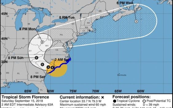
Florence has been downgraded to a tropical storm with diminished winds, but it has stalled over the Wilmington region as predicted and will continue drenching the area with historic and catastrophic rain, the National Hurricane Center said in a 5 a.m. briefing.
The storm had maximum sustained winds of 50 mph as of 5 a.m., the briefing said. But its progress had slowed to a crawl of 5 mph. That, and the storm’s vast circumference of hundreds of miles, means Wilmington will be inundated with rain, the advisory said.
“The Wilmington region could see “storm totals between 30 and 40 inches along the North Carolina coastal areas south of Cape Hatteras. This rainfall will continue to produce catastrophic flash flooding and prolonged significant river flooding,” the advisory said.
Florence’s eye made landfall over the Wrightsville Beach water tower about 7:15 a.m. Friday, according to the National Weather Service (NWS) office in Wilmington. It hit the coast as a Category 1 storm with 90 mph maximum sustained winds, the NWS said. As of 5 a.m. Saturday, the storm’s center was about 35 miles west of Myrtle Beach, according to the National Hurricane Center.
The storm’s arrival brought a 105 mph wind gust at the NWS office about 7 a.m. Friday, said meteorologist Jordan Baker. He said the gust was the strongest recorded in Wilmington since 1958.
>>READ MORE: Click here for complete coverage of Hurricane Florence.
By Friday evening, the Cape Fear River in Wilmington saw storm surge flowing north being met with rainwater flowing west, giving the water nowhere to go. It had crested parts of the downtown river walk by the evening hours.
Other areas throughout the region reported flooded and impassable roads, downed trees and power lines and power outages of more than 125,000 customers. So far, at least three people have died because of the storm, including a mother and infant who were in a Mercer Avenue house when it was struck by a felled tree.
And weather officials said more is coming, labeling as “extreme” the impacts from storm surge and flash flooding.
“The slow motion of the storm will make this a very prolonged flood event,” Reid Hawkins, science officer for the National Weather Service office in Wilmington, said in a briefing. “Catastrophic flooding, long term major river flooding, life-threatening storm surge, and wind damage are occurring or imminent. Major to record river flooding is likely through the upcoming week, especially for those basins that receive significant rainfall.”
Reporter Tim Buckland can be reached at 910-343-2217 or Tim.Buckland@StarNewsOnline.com.