- National memorial to honor NC firefighter who died on duty during Hurricane Helene
- Gov. Josh Stein extends State of Emergency for western NC wildfires
- Gov. Stein extends state of emergency for NC wildfire threat
- Governor Stein extends state of emergency for NC wildfire threat
- Governor Stein extends emergency in 34 NC counties amid wildfire threat
Track shifts could change Florence’s impact on Midlands, but storm warning remains

Hurricane Florence was downgraded to a tropical storm Friday, but it continues to be a threat to the Midlands.
The center of the weakening storm is forecast to reach the Midlands by Saturday afternoon or night, according to the National Weather Service office in Columbia.
But what Florence’s impact on the Midlands will be is no certain thing “because of possible track shifts late Friday night and Saturday,” NWS Columbia reported. “Rainfall amounts could vary substantially over a rather short distance.”
What is known was that as of 11 p.m. Friday, Florence’s maximum winds were recorded at 65 mph while it was hovering near Conway, NWS Columbia reported.
Earlier Friday, most Midlands counties were placed under a storm watch or warning, including Richland and Lexington counties — which were issued a tropical storm warning.
Tropical storm force winds (35 to 45 mph, with gusts up to 55 mph) are expected in the areas under the tropical storm warnings.
“The maximum winds will slowly weaken with time (diminishing on Sunday), but the largest threat will be from heavy rain and flooding,” NWS Columbia said in a news release.
NWS Columbia reported at 11 p.m. that a flash flood watch was still in place for Richland and Lexington counties, among many others in the area.
“The strong wind gusts may down trees and power lines. The heavy rainfall will increase the risk of trees uprooting and toppling,” according to a NWS Columbia news release. “The strong winds will also blow around any loose objects, lawn furniture and trash cans.”
The highest wind gust in the Midlands as of early Friday evening was 51 mph at Shaw Air Force Base in Sumter. A 32 mph gust was recorded at Columbia Metropolitan Airport.
The winds were already causing problems.
Several roads in Lexington County were closed because of downed trees and utility lines, the county reported. They included Corley Mill Road, Old Chapin Road, Catawba Trail and Wyatt Way.
SCE&G reported more than 1,925 customers across South Carolina were without power as of 11 p.m. Many were located in the Midlands, as 1,224 of the outages were reported in Richland County, and 77 more in Lexington County.
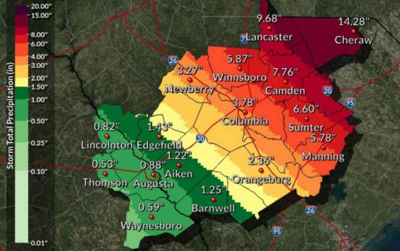
Isolated tornadoes will be possible in the northern Midlands and Pee Dee area, which are expected to get between 8-15 inches of rain, according to NWS Columbia.
“The largest threat will b e from heavy rain and flooding,” according to a National Weather Service statement. “Storm rainfall totals of 3 to 8 inches may occur across the central Midlands.”
The heavy rainfall will “produce areas of flooding across the Midlands,” and even though weather conditions are expected to improve Monday, “flooding on the area rivers will increase as the runoff from heavy rains moves through the river basins,” per NWS Columbia.
NWS Columbia reported that there is the possibility for more changes in the track and intensity in the coming days.
Tropical Storm Warning
A tropical storm warning is in now effect for Chesterfield, Lee, Sumter, Clarendon, Calhoun, Orangeburg, Lancaster, Kershaw, Fairfield, Richland, and Lexington counties, according to NWS Columbia.
Flash Flood Warning
NWS Columbia reported a flash flood watch is in effect for Lancaster, Chesterfield, Newberry, Fairfield, Kershaw, Saluda, Lexington, Richland, Lee, Sumter, Orangeburg, Calhoun, and Clarendon Counties.