- National memorial to honor NC firefighter who died on duty during Hurricane Helene
- Gov. Josh Stein extends State of Emergency for western NC wildfires
- Gov. Stein extends state of emergency for NC wildfire threat
- Governor Stein extends state of emergency for NC wildfire threat
- Governor Stein extends emergency in 34 NC counties amid wildfire threat
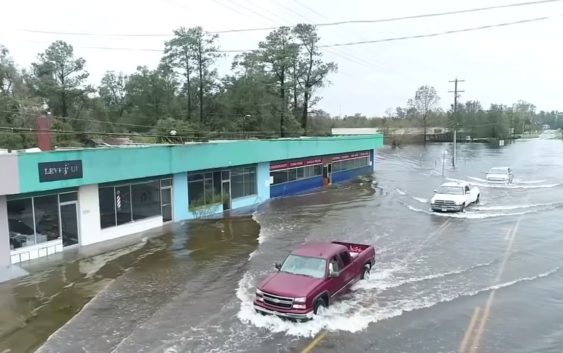
Florence flooding: Drone footage shows hurricane damage in Wilmington
WILMINGTON, N.C. (WTVD) —
Hurricane Florence has been lashing the Carolinas since last week.
By Sunday night, the storm dumped more than 23 inches of rain on Wilmington.
In addition to the nearly two feet of rain, Florence brought heavy winds to the area, which knocked down trees and power lines across the city.
Read more: Flooded Wilmington picking up pieces after Florence’s devastation
Video from Drone11 shows cars trying to navigate through the floodwaters.
The NC Flood Inundation Mapping and Alert Network has created an amazing piece of software that allows users to hone in on a specific river in their area and see where the water is predicted to flood out to.
Click here for a demonstration on how to use the site.
(Copyright ©2018 WTVD-TV. All Rights Reserved.)