- Big March storm system threatens US with tornadoes, blizzards and wildfire risk
- As city leaders consider expanding at-risk zone for wildfire damage, home builders say it could raise costs
- Is your neighborhood at high wildfire risk? | Here's how to check the city's wildfire risk map
- 'Be prepared now': Brad Panovich updates severe weather risk for Sunday
- 'Be prepared now': Brad Panovich updates severe weather risk for Sunday
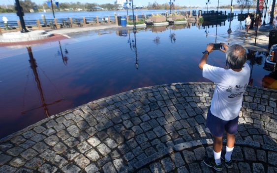
Flooding builds in downtown Wilmington

Cape Fear River to approach record levels due to Hurricane Florence. U.S. 17 remains ‘only safe route’ into town.
WILMINGTON — Brent Garlington shook his head while standing on Market Street looking out toward the Cape Fear River on Sunday morning. In front of him, parts of Water Street were already nearly a foot underwater as flooding from Hurricane Florence made its way to Wilmington.
“I just wanted to see how bad it was,” said Garlington, who was visiting Wilmington from Fayetteville with his son, Thomas. “I just wanted to come down and see it firsthand. It’s so sad.”
And more is coming.
The National Weather Service said the river’s downtown levels, thanks to both floodwater from upstream and tides brought by a nearly full moon, will see the Cape Fear River crest at nearly its record of 8.2 feet, which was set Oct. 8, 2016, after Hurricane Matthew.
“You have to go back to before 1954 to see levels at 8 feet” before Matthew, said Mark Bacon, a meteorologist with the National Weather Service Office in Wilmington. “People like to compare things to (1999 Hurricane) Floyd’s crest. Floyd’s was 7.3 feet.”
Officials with Wilmington Downtown Inc. and Wilmington Fire Department had already warned business owners of the incoming flood waters and passed out sand bags in the last few days.
Roads closed
The rising waters will mean levels of up to 3 feet on Water Street and likely will see yet another major road — U.S. 421 near the Battleship North Carolina — closed because of flood waters, Bacon said. Another part of U.S. 421 near the Pender County line remained closed Sunday after the road was washed over by flood waters.
The stretch near the Battleship is one of the primary access roads for the Cape Fear Memorial Bridge.
“We’re going to see what we saw similar to Matthew’s floods,” Bacon said. “This (will happen) especially as the work week starts.”
Karen Collette, division engineer for the N.C. Department of Transportation region that includes Southeastern North Carolina, said U.S. 17 from the north or south remains the only safe route into and out of Wilmington.
Parts of Interstate 40 and U.S. 421 remained impassable Sunday and Collette said officials still have to determine the extent of damage the roads, and many others, suffered during the storm.
Tom Collins, emergency management director for Pender County, said numerous roads in the county remain impassable. Portions of N.C. 53 were under as much as 7 feet of water during the height of the storm. That, combined with parts of I-40 being closed, has led to other traffic issues.
“Now, we have all of this traffic on roads we normally don’t have,” Collins said.
Pender flooding
Collins estimated that about 3,000 homes flooded during Hurricane Florence and the storm’s aftermath.
“There are some places that got flooded that I’ve never seen flood before,” he said.
Collins said crews planned to begin Sunday to try to reach places impacted by flood waters.
“We still have a lot of places we just haven’t been able to get to yet,” he said. “It’s going to be horrendous. We’ve still got a lot of work to do.”
He cautioned, though, that officials aren’t sure yet just how many buildings were impacted.
“I might be underestimating,” he said.
Numerous people, even those with homes flooded by several feet of water, have refused to accept offers to stay at shelters.
“They won’t leave,” he said. “They want to protect their property.”
Sutton breach
Officials are keeping an eye on a major breach of the Sutton Plant dam upstream of Wilmington. The Cape Fear River toppled the dam Friday and brought with it the threat of coal ash washing into the river.
On Saturday, Duke Energy released a report citing stability at the plant despite the river overtopping the northern section of a cooling lake dam and exiting through a breach on the southern end of the cooling lake. In its path was the 1971 coal ash basin.
Kemp Burdette, the Cape Fear Riverkeeper, said Sunday that his group has seen coal ash make its way into the river during boat trips near the area. Duke officials have maintained that the energy company “had no indication” that coal ash had escaped the basin.
Reporter Tim Buckland can be reached at 910-343-2217 or Tim.Buckland@StarNewsOnline.com.