- Austin leaders consider expanding wildfire protection plan
- Large hail, strong winds and tornado threat possible into Thursday evening
- Large hail, tornado threat possible Thursday evening
- Jaccob Slavin scores in OT as the Hurricanes beat the Capitals in Game 1 of their 2nd-round series
- 5 On Your Side: What happened to cars flooded during Hurricane Helene?
Nat'l Weather Service: Florence was unique in many respects

‘It didn’t just defy a model, it defied history’
WILMINGTON — If history was any indication, Hurricane Florence should have never reached the Cape Fear region.
Two weeks after the devastating storm, meteorologists and climatologists are still studying Florence to understand what made it such a unique storm that left forecasters to rely on other resources to predict it approach.
“It didn’t just defy a model, it defied history,” said Steven Pfaff, warning coordination meteorologist with the National Weather Service’s Wilmington office. “With any storm, we look for whether this has happened before and followed a similar track. When we didn’t see that, it made it more of a challenge to forecast.”
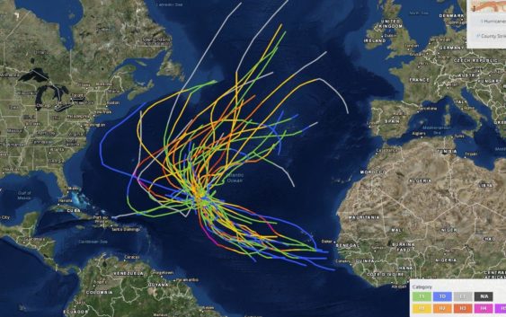
The track is one of the most unique things about Florence.
Pfaff said most of the storm that reach the East Cast form more south in the Atlantic and track up near Puerto Rico. Florence formed farther north, off the west coast of Africa.
“Our pipeline of hurricanes is a latitude equal of the Caribbean Islands or there about,” Pfaff said. “We have never had a storm hit the East Coast at a such a northern latitude.”
Pfaff said the storm’s ability to continue the long journey to the Carolinas was assisted by a high pressure system to its north, pushing it south and defying models that typically see storms from that region curving north.
Once it reached land, the storm also took forecasters by surprise. The angle of incidence at landfall — or where it goes after it starts affecting land — did not follow the standard north or south track for more storms with an eye on the Carolinas.
“It barreled due west, when most go south to north,” Pfaff said.
The last trait that struck Pfaff was just how long it impacted Southeastern North Carolina.
Florence stalled over the region for nearly three days, bringing wind, rain and the threat of more severe weather, a defiance of most hurricanes that move in and move out.
“The high pressure to its north moved and just left the storm here,” Pfaff said. “Because it just sat here, we saw a incredible amount of (impacts). First it was strong winds from the eye and storm surge, then it switched to a tornadic event and then ended with river flooding and trillions of gallons of water.”
Florence was a storm of defiance. But Pfaff said it made that clear early and allowed teams to put in place equipment to capture and measure its strength so it can be studied and prepared for.
A Doppler radar was put on an Interstate 40 bridge in Brunswick County to measure wind speeds. A GO satellite captured high-resolution data on how a storm transforms itself.
“For many of us who have been here for 20 years, Florence will certainly be one for our careers,” Pfaff said. “But there was a lot of scientific work ramped up before it even got here so that we can learn from it.”
Reporter Hunter Ingram can be reached at Hunter.Ingram@StarNewsOnline.com.