- After Hurricane Beryl, Texas lawmakers push for generators at senior living facilities
- 20-million-gallon detention basin in Meyerland designed to help prevent flooding
- Firefighters report significant progress on McDowell County wildfire
- How to watch the FireAid benefit concert for LA wildfire relief
- FireAid, a benefit for LA wildfire relief, is almost here. Here’s how to watch and donate
When will the Triangle feel effects from Hurricane Michael? And how long will they last?
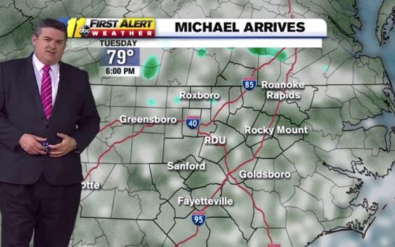
Triangle residents are once again keeping an eye on a hurricane, with the outer bands of Hurricane Michael possibly bringing heavy rain, wind and maybe even an isolated tornado.
Don “Big Weather” Schwenneker of ABC11 tells us what Raleigh, Durham and Chapel Hill residents need to know about this storm and what we might expect.
When will the Triangle feel anything from Hurricane Michael?
You could see some showers late into Wednesday night out ahead of it. I don’t think the bulk of the heavy rain will arrive ‘til midday on Thursday, at least, and then Thursday afternoon and evening, certainly, there will be heavy pockets of rain around.
The winds will start to pick up Thursday morning. I think by midday Thursday, you’ll be seeing the heavier rain and wind working through.
How much rain is expected in the Triangle?
There’ll be a little leading up to it Wednesday, but by the time it’s all done Thursday night or very early Friday, in the Triangle it could be 2 to 4 inches. There’s a potential to see 5 to 6 inches in a few outlying spots. Still some question marks — one of the models keeps the bulk of the heavy rain to the south, so the European [model] keeps it way south.
The American model keeps it to the north. I like to go with the National Weather Service and the Weather Prediction Center, and they kind of split the difference between the two models.
How strong will the winds be?
In the Triangle, we’ve got a 30 to 40 percent chance of seeing a tropical storm force wind — that’s a wind that’s sustained for one minute or longer, at 39 mph or greater. I do think there’s a possibility of wind gusts up around 50 mph, just a quick burst every now and then.
That would also be mainly through Thursday. Thursday midnight or Friday at 3 a.m or 4 a.m., this storm is pulling out of here. It’ll still be breezy on Friday — you’re talking 20 mph winds instead of 40 mph winds. And it will dry out Friday. We’ll see sunshine moving back in Friday. It’ll be a gorgeous weekend.
Should we be worried about flooding?
That’s our biggest concern. Right now, if I were to pick one type of severe weather, I’d up my category for flooding than anything else only because the ground is so saturated. If we get a couple inches of rain, the ground isn’t going to be able to catch much of that because it’s still so wet. It’s almost like a sponge.
I think we could see some localized flash flooding, especially in areas that are prone to it. As far as river flooding goes, I don’t think it will be as high as it was for Florence. But once this all runs off, you could see some rivers going into minor to moderate flood stages. That would be a little bit later, probably Friday and into Saturday.
Flooding is the biggest threat. An isolated tornado and power outages aren’t out of the question. Between the saturated ground and the amount of branches that could come down, I think some folks could lose power.
How is this storm different from Hurricane Florence?
The biggest difference is Florence took forever to move — a couple of days. It was a slow mover, so the rain kept pounding and pounding. This thing will be through our state in less than 24 hours.
It’s still going to drag up a lot of moisture from the Gulf, that’s why the potential is there to see heavy rainfall. Michael is coming from the southwest.
Will the western part of the state feel an impact?
The biggest rain could fall from here to Charlotte, but the entire state will see rain as this thing works through. It’s a pretty big storm. Once it starts to get out toward the mountains it drops off to possibly half inch to 2 inches.
When will the hurricane be out of the area?
There’s a chance this thing hits land and it slows down a little bit, but at the current speed and forecast, we could see the rain done before daylight Friday. We could actually see a nice afternoon on Friday.
The same front that’s gonna shove this storm out quickly is going to bring us cooler air behind it. For the first time this season, it’ll feel like fall. On Thursday, the high temperature is going to be in the low 70s. On Saturday, some places may not get out of the 60s. And then on Sunday, again, in the low 70s. Our normal high this time of year is 75.