- Another $500M for Hurricane Helene relief in North Carolina passes key hurdle
- Crews battle wildfire in McDowell County, NC
- Wildfire in McDowell County, NC is 20% contained, officials say
- California governor asks Congress for nearly $40 billion for Los Angeles wildfire relief
- North Buncombe High School students lead recovery efforts for NC farmers post-Hurricane Helene
Early Thursday, Midlands will get heavy rains, strong winds as Hurricane Michael hits
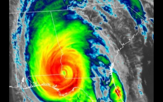
After it moved through Florida and Georgia, Hurricane Michael is expected to hit South Carolina early Thursday morning.
Shortly after that, Columbia and the Midlands will feel the effects of the deadly storm.
Starting at 4 a.m., heavy rains and powerful winds will start lashing Richland and Lexington counties, according to National Weather Service meteorologist Frank Alsheimer.
Michael is expected to have weakened from a Category 1 hurricane to a tropical storm by that time, but will have an impact on the region.
“Heavy rains will start around 4 a.m. and the winds will start picking up in gusts,” Alsheimer told The State, adding “The strongest winds will be between 7 a.m. to noon.”
A brief break in the powerful weather will be followed by a few more hours of rain and wind before conditions are expected to improve in the afternoon or early evening, according to the NWS.
By Thursday night, 4-6 inches of rain is expected to fall in the Midlands, according to the NWS.
“A lot of that will fall in the morning hours of 4 a.m. to noon,” said Alsheimer, who warned of possible flooding and ponding of water. “Flood-prone areas will likely be problems and could cause a rise on the rivers. (More flooding) is something to keep an eye on for the weekend.”
A flash flood warning has been issued for most Midlands counties, in addition to a tropical storm warning.
Any winds greater than 39 mph are tropical storm winds. The forecast is calling for winds between 30 to 40 mph, with gusts as high as 50 mph, the NWS reported.
Alsheimer said major structural damage is not expected to be caused by Michael, but tree limbs and powerlines are predicted to fall during the storm.
The combination of wind and rain will make for a treacherous morning commute, according to Alsheimer. The NWS is asking drivers to stay off the road if possible, but those who will be making their way to work need to give themselves extra time for their rides on Thursday morning.
“Traveling is going to be difficult,” Alsheimer said. “We urge them to prepare to travel slower.”
Another factor that could make the morning commute even more difficult is the potential for tornadoes.
The NWS reported that the threat for a few tornadoes is elevated, especially during the morning hours in the area just south of the I-20 corridor.
The areas to the south and the east of Columbia, from the Lowcountry to the Pee Dee region are at the greatest risk of tornadoes as the storm moves to the northeast and the North Carolina state line.
Michael made landfall on the Florida Panhandle shortly after 1 p.m. Wednesday as a Category 4 hurricane, according to the National Hurricane Center. The storm’s maximum sustained winds at the time of landfall were 155 mph.
But because of all the ground it has covered since hitting the Florida Panhandle, it has lost the “worst of its punch,” Alsheimer said.
He explained that Michael is not predicted to have the impact that Florence had on South Carolina less than a month ago.
“This is a very different type of storm,” Alsheimer said. “There are more tornado threats and wind threats, but we don’t expect the devastating damage that Florence had … even though it will affect a good deal of South Carolina.”