- Driver dies after crashing off hurricane-damaged highway in North Carolina
- Body buried in North Carolina carried to Tennessee by Hurricane Helene floodwaters
- Wind damage from Helene could be worst since Fran and Hugo
- Hi-Wire Brewing continues to recover after Hurricane Helene
- Fired FEMA worker explains why she directed employees to avoid helping hurricane victims who supported Trump
Hurricane Michael North Carolina weather: Gov. Cooper warns 'Michael is still a threat'

NORTH CAROLINA —
Gov. Roy Cooper and other state leaders warned citizens to take Tropical Storm Michael seriously.
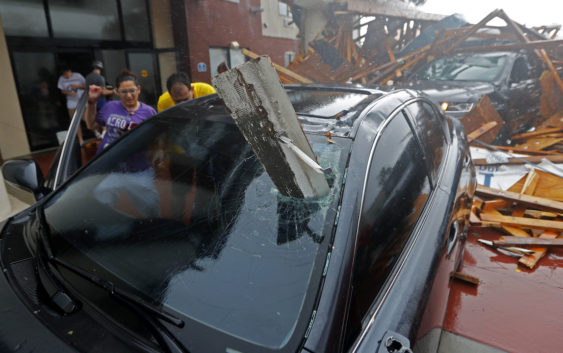
Hurricane Michael hit the Florida Panhandle on Wednesday afternoon, swept through Georgia — killing at least two people — and is now entering the Carolinas, which are still reeling from epic flooding by Hurricane Florence.
While the hurricane has weakened to a tropical storm, Cooper said people should still take precautions.
“Inland hurricanes and tropical storms are life threatening and can do just as much damage as coastal storms,” Cooper said.
A Tornado Watch is in effect for much of North Carolina and Virginia.
The Tornado Watch lasts until 9 p.m. and covers the following North Carolina counties: Alamance; Beaufort; Bertie; Bladen; Brunswick; Camden; Carteret; Caswell; Chatham; Chowan; Columbus; Craven; Cumberland; Currituck; Dare; Davidson; Duplin; Durham; Edgecombe; Forsyth; Franklin; Gates; Granville; Greene; Guilford; Halifax; Harnett; Hertford; Hyde; Johnston; Jones; Lee; Lenoir; Martin; Nash; New Hanover; Northampton; Onslow; Orange; Pamlico; Pasquotank; Pender; Perquimans; Person; Pitt; Randolph; Rockingham; Sampson; Tyrrell; Vance; Wake; Warren; Washington; Wayne; Wilson.
Michael was said to be the most powerful hurricane on record to hit Florida’s Panhandle.
Stay on top of breaking news stories with the ABC11 News App
The devastating storm was downgraded to a Tropical Storm and is expected to arrive in North Carolina late Thursday morning.
Timeline of the storm
9 a.m.: Rainfall starts in the Sandhills
11 a.m. – 2 p.m.: Heavier rain starts to fall across the area
3 p.m. – 7 p.m.: Heaviest rainfall occurs
7 p.m.: Heavy rains start to taper off, dry spots form
8 p.m. – 10 p.m.: Storm pushes out of the area
Rainfall amounts will average 2-4″ inches.
Areas near Raleigh can expect to see between 2-4″, areas surrounding Person County could see 5-7″, and the coastal region could see between 1-3″.
Local power outages and minor structural damage will be possible; Duke Energy is expecting between 300,000 to 500,000 outages in the Carolinas.
Local rivers and streams, which were recently affected by Hurricane Florence, could see some flooding from Tropical Storm Michael.
Cape Fear River crests higher than Hurricane Matthew
On Wednesday, the Cape Fear River crested high than it did during Hurricane Matthew.
Some rivers are expected to crest — or reach the highest stage or level of a flood wave as it passes a particular point — at moderate flood stage Friday night and Saturday morning.
High winds are also a possibility. Many areas could be gusts up to 40 mph.
Big Weather said Isolated tornadoes are possible as well.
(Copyright ©2018 ABC11-WTVD-TV/DT. All Rights Reserved – The Associated Press contributed to this report.)