- Trump approves federal assistance amid Arkansas flooding
- Weather Impact Alert: Tornado Watch issued for much of Southeast Texas until 9 p.m.
- Colorado State University predicts above-average 2025 Atlantic Hurricane Season
- South and Midwest face potentially catastrophic rains and floods while reeling from tornadoes
- Deadly 2024 hurricanes prompt WMO to retire three names
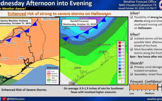
Trick-or-treaters could face severe weather this Halloween
-
Photo: National Weather Service Houston/Galveston
Photo: National Weather Service Houston/Galveston
Spooky weather is in the forecast this Halloween, with trick-or-treaters expected to encounter severe thunderstorms later tonight.
Kids might have their best shot at raking in the candy before 6 p.m., according to the National Weather Service. The highest chances of storms, moving along an incoming cold front, start around then and last until a few hours after midnight.
The Houston area will see an 80 percent chance of scattered showers and thunderstorms this afternoon, with a quarter to a half-inch of rain forecast.
Later tonight, expect severe thunderstorms, which should cause rainfall of 1 to 2 inches.
The National Weather Service warns that rain could cause roadways to pond and flood cars in low-lying areas.
Creeks and bayous could rapidly rise but aren’t expected to exceed their banks, meteorologists said.
Severe storms could produce tornadoes, wind damage, large hail and locally heavy rainfall, according to the National Weather Service’s Houston/Galveston office.
Highs are forecast at 84 degrees today, with lows reaching 59 degrees. High temperatures will dip to the high 60s on Thursday.