- Weather Impact Alert: Brad Panovich updates severe weather risk on Sunday
- Big March storm system threatens US with tornadoes, blizzards and wildfire risk
- As city leaders consider expanding at-risk zone for wildfire damage, home builders say it could raise costs
- Is your neighborhood at high wildfire risk? | Here's how to check the city's wildfire risk map
- 'Be prepared now': Brad Panovich updates severe weather risk for Sunday
Dense fog advisory, severe weather risk threaten Election Day
Raleigh, N.C. — Severe storms could dampen Election Day by the evening commute, but WRAL meteorologist Elizabeth Gardner said the real issue Tuesday morning is dense, thick fog from the Triangle westward.
A dense fog advisory is in effect for Wake County and counties to the west until 9 a.m.
Light ran began falling Monday night as thick fog reduced visibility to less than 1 mile. Early morning voters and those headed to work should use extra caution and turn on low-beam headlights.
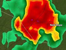
After a damp morning, the sun is expected to peak out as temperatures rise into the 70s during the afternoon before a narrow band of storms makes its way into the state from the west.
Storms should begin in the western counties by about 2 p.m. but will move through the state quickly. They should be over the Triangle by about 4 p.m. and will have moved on to the eastern part of the state by about 5 p.m.

Despite the speed of the system, the chance for severe weather remains, with a slight risk for damaging winds or an isolated tornado. The risk is highest in eastern counties, where the sun will be out for a long time during the afternoon, creating instability in the atmosphere to fuel the storms.