- National memorial to honor NC firefighter who died on duty during Hurricane Helene
- Gov. Josh Stein extends State of Emergency for western NC wildfires
- Governor Stein extends state of emergency for NC wildfire threat
- Governor Stein extends emergency in 34 NC counties amid wildfire threat
- Texans can buy emergency preparation supplies tax-free April 26-28 ahead of severe weather season
NWS: Severe thunderstorms may bring tornadoes, hail, flooding, heavy winds to San Antonio area

-
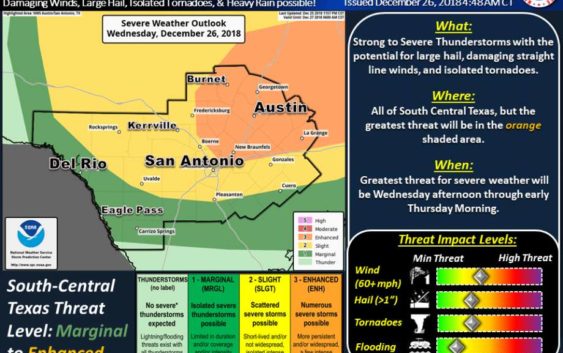
The National Weather Service said the thunderstorms expected to hit South Central Texas on Wednesday may bring tornadoes, hail, flooding and heavy winds.
The National Weather Service said the thunderstorms expected to hit South Central Texas on Wednesday may bring tornadoes, hail, flooding and heavy winds.
Photo: National Weather Service
The National Weather Service said the thunderstorms expected to hit South Central Texas on Wednesday may bring tornadoes, hail, flooding and heavy winds.
The National Weather Service said the thunderstorms expected to hit South Central Texas on Wednesday may bring tornadoes, hail, flooding and heavy winds.
Photo: National Weather Service
The thunderstorms expected to hit South Central Texas on Wednesday may bring tornadoes, hail, flooding and heavy winds, according to the National Weather Service.
Cloud cover may initially limit the affects of the storm as it passes over Bexar County and surrounding areas Wednesday afternoon. During this initial period of the storm, the greatest threat will be large hail, according to the NWS.
FIND OUT FIRST: Get San Antonio breaking news directly to your inbox
At around midnight Thursday, the upper level storm system and cold front responsible for the nasty weather will reach the Interstate 35 corridor. When that occurs, the NWS said, the primary threat will shift to heavy winds and the possibility of isolated tornadoes “as the environment will support the development of rapid spin-ups along the leading edge of the thunderstorm line.”
Bexar County is expected to receive about 1 to 1.5 inches of total rainfall, beginning Wednesday afternoon. Areas east of I-35 and north of Interstate 10 could receive up to 3 inches of rain. The NWS said the expected speed at which the storms will be traveling could limit the threat of flooding.
Text “NEWS” to 77453 for breaking news alerts from mySA.com
Caleb Downs covers crime in San Antonio and Bexar County. Read him on our breaking news site, mySA.com, and on our subscriber site, ExpressNews.com |
cdowns@mysa.com | @calebjdowns