- One set of evacuation orders lifted in Caldwell County after wildfire contained
- 'We gutted every building' | Chimney Rock rebuilding after Hurricane Helene
- 'We gutted every building' | Chimney Rock rebuilding after Hurricane Helene
- Debris from Hurricane Helene provides fuel, complicates containment for spring wildfires
- David & Nicole Tepper increase Hurricane Helene relief commitment to $750k
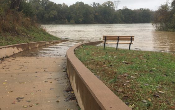
More rain coming to York County, as forecast warns of flooding on already high waters

More rain is expected to fall in York County and surrounding areas, and experts are urging caution around lakes and rivers.
Duke Energy on Wednesday released a safety message for area lakes along the Catawba River Basin. Four lakes are expected to pass flood levels and several sit within inches of joining them. Duke again said Lake Wateree, south of Lancaster, could rise to 3 feet above flood level.
“Significant rainfall is forecast for the Catawba River Basin,” the message states. “Reservoirs have had little chance to recover and the ground is very saturated. Additional rainfall can cause higher lake levels. The Duke Energy hydro operations team continues to aggressively move water through the river system with spillway gates open at Wylie, Fishing Creek and Cedar Creek hydro stations.”
Residents living along lakes, streams and low-lying, flood-prone areas should use caution, according to the message.
$20 for 365 Days of Unlimited Digital Access
Last chance to take advantage of our best offer of the year! Act now!
#ReadLocal
Lake Wylie, one of 11 reservoirs on the Catawba River chain, rose almost a foot higher than its target elevation Wednesday but still had a couple more feet before reaching full pond, the point when a lake begins to spill or flood. A four-day span ending Jan. 1 saw Lake Wylie rise to within 2 feet of its full pond or higher. On Dec. 21, the lake reached its highest point in more than a month, at about 6 inches below full pond.
Of the 11 lakes on the Catawba chain, five have reached and exceeded full pond in the past week. They include lakes James, Rhodhiss, Lookout Shoals and Mountain Island Lake, upstream of Wylie, and Lake Wateree downstream.
On Wednesday, the National Weather Service issued a hazardous weather outlook for counties throughout northeast Georgia, piedmont North Carolina and upstate South Carolina, including York and Chester.
“Widespread rain will develop across the region late Wednesday into early Thursday as a frontal system moves over the region,” the alert said. “A brief dry period may occur Thursday afternoon and evening, however in response to low pressure moving up from the Gulf Coast, another period of moderate to heavy rainfall is expected on Friday. With soils still soggy in many areas from the recent rainfall, these upcoming rain events may result in more flooding late this week. Flooding is especially likely along rivers that remain at elevated stages.”
National Weather Service data shows most of York, Lancaster and Chester counties received between 50 and 60 inches of rain in 2018, some areas as high as 70 inches. The average annual rainfall in York County is 43 inches.
The record annual rainfall in Charlotte, according to the weather service, is more than 68 inches in 1884. Charlotte had 59 inches in 2018.
River and lake access points have been closed in recent weeks because of high water levels. Rock Hill closed access points at River Park and Riverwalk. Tega Cay also closed its access near the Lake Wylie dam. The city posted a video on social media in late December showing water pouring from the dam and water levels well above normal at a launch site.