- Sellers and Rantanen are among the NHL trade deadline winners. Hurricanes and Boeser are some losers
- Hurricane forecasters express concern over NOAA job cuts impact
- FEMA deadline for Hurricane Helene recovery aid extended again
- Tornado drills to take place at schools across North Carolina Friday morning
- Hays County emergency alerts cause confusion during Tuesday's wildfires
Carolinas hit by strong storms as multiple counties issued tornado watches
CHARLOTTE, N.C. — It’s been a wet and stormy weekend with expected severe storms on Sunday. Chief meteorologist Brad Panovich said any one of the scattered showers coming in waves Sunday has the potential to produce severe weather or even tornadoes.
NBC Charlotte’s First Warn Storm Team is tracking severe storms working through the Carolinas.
A tornado watch was issued for Gaston, Iredell, Lincoln, McDowell, Mecklenburg, Rowan, Rutherford and Stanly County in NC until 8 p.m.
A tornado warning was issued for Rutherford County until 3:45 p.m., with a storm Panovich said is moving close to 50 mph.
Along with a lot of wind energy and instability in the atmosphere Sunday, West Virginia mountains and possibly even North Carolina mountains could be getting snow.
Panovich said storms are expected to enter the mountains and move into the Piedmont around 3:30 to 4 p.m., and in several batches. He said all could have the potential for wind and hail.
Saturday, scattered thunderstorms, showers and tornado warnings caused several roads across the region to flood. Be on the lookout for any road closures on Sunday.

WCNC
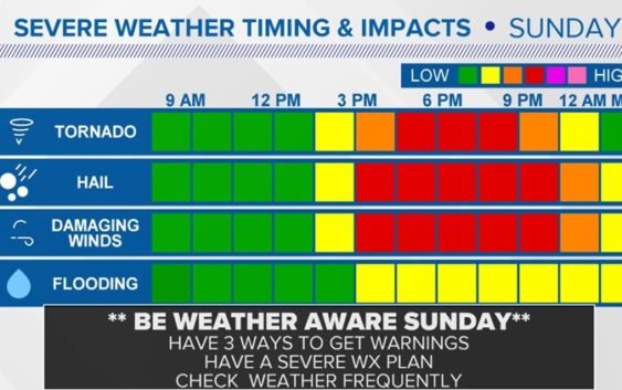
The tornado threat is expected to peak mid to late afternoon Sunday. A lot of the severe weather is expected to come after 2 p.m. Wind and hail threats peak after 3 p.m. to about 9 p.m. Flooding concerns stay elevated through about midnight, though.
“That changing of wind direction is pretty potent energy,” Panovich said. “If we get any breaks in the clouds at any point on Sunday, that will allow for thunderstorms to build into that column of air and you get rotating storms.”
Panovich said those rotating storms don’t always bring tornadoes, although that is a serious threat. The storms could always bring hail, heavy rain and damaging winds to the Charlotte area.
The good news is the weekend won’t be a total washout. Panovich said the showers will be off and on throughout the day on Saturday and Sunday. Any all-day events outside will be impacted, though.
“If you have outdoor plans, the best thing I can tell you at this stage is you’ve got to have a plan,” Panovich said. “If you’ve got an activity where you can wait out a 15 or 20-minute shower, and then get back out, you’re fine.”
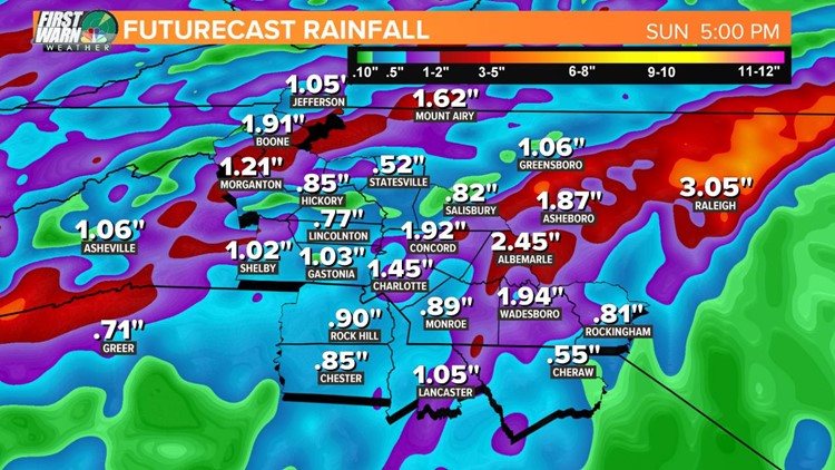
Some areas around Charlotte could see more than 2 inches of rain, while Sprinkle expects the Queen City to get around an inch-and-a-half.
By Sunday evening rainfalls totals could be:
- .85 Hickory
- 1.03 Gastonia
- 1.45 Charlotte
- 1.92 Concord
- 1.94 Wadesboro
- 2.45 Albemarle
WCNC
RELATED: More storms hit Charlotte after severe weather leaves trail of damage
RELATED: Charlotte sees first measurable April snow in 37 years
Less than two weeks into the month and Charlotte’s already seen a little bit of everything from Mother Nature. On April 1, the first measurable snow fell in Charlotte since 1982. That quickly gave way to spring-like temperatures and an explosion of pollen in the Carolinas.
Some people even called it the “pollen apocalypse.” Scott says there’s good news, though. We’re on the downward trend of the pollen season, so if you’re suffering from springtime allergies, try to hang in there for a few more weeks.