- National memorial to honor NC firefighter who died on duty during Hurricane Helene
- Gov. Josh Stein extends State of Emergency for western NC wildfires
- Gov. Stein extends state of emergency for NC wildfire threat
- Governor Stein extends state of emergency for NC wildfire threat
- Governor Stein extends emergency in 34 NC counties amid wildfire threat
Severe thunderstorm risk increases late Sunday; tornado watch issued
Most of Sunday will be warm and cloudy but there is a risk for a strong thunderstorm with damaging wind and flash flooding later in the day.
![]()
Several parts of the viewing area are under Tornado Watch until 8 p.m. Click here for a list of counties.
A tornado watch has been issued for much of central North Carolina until 8:00pm. pic.twitter.com/b9mvOMTZc2
— Brittany Bell (@BrittanyABC11) April 14, 2019
Risk for severe weather elevated this afternoon and evening. Main threat will be straight-line winds. Estimated time for greatest risk will be mid to late evening. pic.twitter.com/7iPrZG2xEW
— Steve Stewart (@StewartABC11) April 14, 2019
The main risk for Saturday are straight-line winds but a brief spin tornado is possible. The hail threat has decreased.
The radar could looks like this later this evening. Strong to severe storms possible later today. pic.twitter.com/Bn7XQO9ZxJ
— Steve Stewart (@StewartABC11) April 14, 2019
A new area of low pressure approaches Sunday and this one has more energy and better severe parameters so our risk for severe weather will be increasing for late in the day into the evening hours.
Sunday has a higher risk for isolated tornadoes as it is possible we could see a better chance for storms to begin rotating.
Stay on top of the latest weather updates by downloading the ABC11 app
On Saturday, Alamance, Durham and Orange counties experienced Flash Flood Warnings.
Some parts of the viewing area saw heavy rain and flooding.
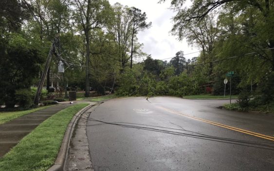
Downed tree and power lines blocking Brooks Ave at Wade Ave in Raleigh
PHOTOS: Heavy rain makes its way through the Triangle and Fayetteville
The ground in many areas was saturated so additional rain caused some minor areas of flash flooding.
Copyright © 2019 WTVD-TV. All Rights Reserved.