- Here’s how Austin-area leaders are preparing for wildfire threats this summer
- Harris County sues Trump administration, cites threat to hurricane season preparedness
- Prescribed burn in Morrow Mountain aims to prevent future wildfires
- Prescribed burns aim to prevent wildfires in Stanly County
- Prepare for hurricane season with the Town of Leland Hurricane Expo
Severe Weather Possible This Evening
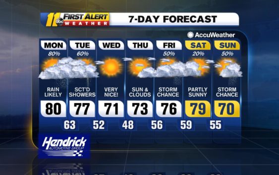
A storm system will lift northeastward through the Tennessee and Ohio valleys today while its cold front presses eastward and reaches the Appalachians by early evening. There will limited sunshine ahead of this frontal boundary to round out the weekend, and some spots can have a shower or thunderstorm. As the front crosses the area later tonight, showers and thunderstorms will be more widespread in coverage, and there is the risk for severe storms. The main concerns with these storms will be localized flash flooding and damaging wind gusts. An isolated tornado is also possible. A tornado watch is in effect through 8pm.

There can be a leftover shower first thing Monday morning, mainly east of the Triangle, then drier and cooler air will filter in later in the day allowing sunshine to return. Highs tomorrow will be nearing 80 ahead of the front, but on Monday, temperatures will do no better than the mid- to upper 60s. High pressure will be in control Tuesday and Wednesday promoting dry conditions and a good deal of sunshine.
Temperatures will recover into the upper 70s by midweek.
Have a safe evening!
Brittany Bell
Check the radar anytime with the free AccuWeather app for iPhone and Android today!
Copyright © 2019 WTVD-TV. All Rights Reserved.