- McDowell County wildfire spreads to 500 acres, evacuation orders in place
- Evacuations in Caldwell County due to wildfire
- Northwest Houston 'ghost neighborhood' caused by repeated flooding to become latest detention basin
- NHL playoffs: Hurricanes open playoffs Easter Sunday afternoon vs. Devils
- 2 wildfires spreading in rugged terrain in western North Carolina
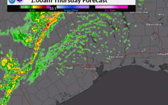
Rain, hail and winds to plague Thursday’s morning commute, Houston meteorologists predict
-
A storm system is expected to bring heavy rain, large hail and damaging winds to the Houston area on Thursday, April 18, 2019.
A storm system is expected to bring heavy rain, large hail and damaging winds to the Houston area on Thursday, April 18, 2019.
Photo: National Weather Service
A storm system is expected to bring heavy rain, large hail and damaging winds to the Houston area on Thursday, April 18, 2019.
A storm system is expected to bring heavy rain, large hail and damaging winds to the Houston area on Thursday, April 18, 2019.
Photo: National Weather Service
We hope you enjoyed your commute to work Wednesday morning, because Thursday’s is predicted to be hellish.
Meteorologists with the National Weather Service say a front currently moving through Central Texas is going to slam Houston with severe storms, heavy winds and possibly hail as early as Wednesday night into Thursday. Localized flooding could also be of concern, they say.
The timing of the storm’s arrival isn’t certain, although NWS officials predict the worst of it could hit the Houston area during the morning rush hour.
There is a silver lining, however: Clear skies and pleasant temperatures through the weekend starting Friday, NWS officials predict.
But before Houstonians can exhale a collective sigh of relief, they must get through this storm first.
Heavy rains could drop as much as 3 inches Wednesday night, creating “localized flooding concerns,” NWS meteorologists say, while the threats of large hail, damaging winds and more rain start early Thursday.
Winds from the west will slowly push the storm system out of the Houston area by late Thursday morning, bringing with it clear skies and low temperatures in the upper 50s Thursday night. Thursday night will also be breezy, NWS officials say.
Good Friday will be a picture-perfect day with clear, sunny skies and high temperatures in the upper 70s. That pleasant weather is predicted to last through Easter Sunday, NWS officials say.
Then, just in time for the start of a new work week, a 20-to-30 percent chance of showers and thunderstorms is predicted for at least Monday and Tuesday.
Jay R. Jordan covers breaking news in the Houston area. Read him on our breaking news site, Chron.com, and our subscriber site, HoustonChronicle.com | Follow him on Twitter at @JayRJordan | Email him at jay.jordan@chron.com | Text CHRON to 77453 to receive breaking news alerts by text message