- Austin adopts new map that greatly expands area at risk of wildfire
- CenterPoint Energy accelerates infrastructure improvements ahead of hurricane season
- Carolina Hurricanes playoff tickets go on sale Thursday
- Ask the Meteorologist: Why do tornadoes target Tornado Alley, Dixie Alley?
- Nonprofit closes distribution site that aided thousands after Hurricane Helene
Raleigh, Sandhills areas under enhanced risk for severe weather on Friday
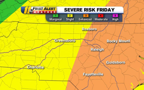
NORTH CAROLINA (WTVD) — Parts of central North Carolina, including the Triangle and parts of the Sandhills, are at enhanced risk for severe weather on Friday.
ABC11 meteorologist Steve Stewart said damaging winds, hail, and isolated tornadoes are possible.
ABC11 meteorologist Steve Stewart said damaging winds, hail, and isolated tornadoes are possible.
Your first alert for severe storms on Friday. Damaging winds, hail ad isolated tornadoes are possible. Rainfall rates will be 2-3″ per hour at times so areas of flash flooding also a risk. Timing for severe threat, afternoon and evening hours on Friday. pic.twitter.com/LkFT2eCRJV
— Steve Stewart (@StewartABC11) April 17, 2019
He said we could see rainfall rates at 2-3″ per hour, so many areas may also see flash flooding.
The storm is a bit far out, but Stewart said the storm’s threats will be higher in the afternoon and evening.
Check the radar anytime with the free AccuWeather app for iPhone and Android today!
Copyright © 2019 WTVD-TV. All Rights Reserved.