- Austin adopts new map that greatly expands area at risk of wildfire
- CenterPoint Energy accelerates infrastructure improvements ahead of hurricane season
- Carolina Hurricanes playoff tickets go on sale Thursday
- Ask the Meteorologist: Why do tornadoes target Tornado Alley, Dixie Alley?
- Nonprofit closes distribution site that aided thousands after Hurricane Helene
Severe Thunderstorm Watch In Effect; Large Hail And High Winds Possible Into Early Thursday Morning
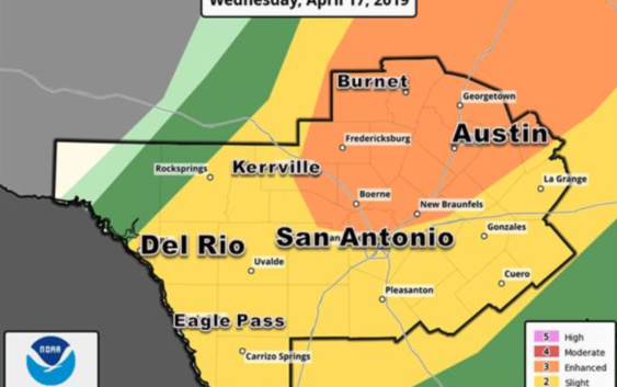
The National Weather Service has issued a severe thunderstorm watch until 2 a.m. for much of the Austin area and the Hill Country.
Large hail and damaging winds are the most likely threats facing this evening and into Thursday morning.
An isolated tornado is also possible, the NWS warns. The weather service puts the chance of precipitation for Austin at 90 percent tonight, with between one-half and three-quarters of an inch of rain possible.
The National Weather Service in Austin/San Antonio tweeted a forecast model showing the brunt of the storms hitting Austin between 11 p.m. and 1 a.m. — noting the actual time and intensity of the storm’s arrival may change.
In an afternoon update Wednesday, the NWS said there has been little to no change in the forecast for the overnight hours.
There has been little to no change in the forecast for this evening and overnight hours. Strong to severe storms are expected to move over the region. Large hail and damaging winds are the main threats. Take a look at your area for your risks as well as when to expect it. pic.twitter.com/zKrwyI9sjJ
— NWS Austin/San Antonio (@NWSSanAntonio) April 17, 2019
RELATED | 8 Ways To Stay Ahead Of Severe Weather In Central Texas
Eric Platt, a meteorologist with the National Weather Service, says the storm will develop out over the Hill Country and come in from the west.
“The hail and the high winds are the biggest concerns at this time, although we can certainly expect frequent cloud-to-ground lightning strikes and some heavy rain as this line of storms moves through the region,” Platt said.
Thursday is expected to be sunny with a high near 74 degrees.