- Long-term closures begin on I-10 Katy Freeway to elevate road, prevent flooding
- Texas firefighters helping battle California wildfires
- Western NC teams helping both hurricane and wildfire victims
- New wildfire warnings issued and more power is shut off as winds rise in Southern California
- In wake of wildfires, Spurs' Chris Paul, Victor Wembanyama give JJ Redick's sons their game-worn jerseys
Panovich: Charlotte could see damaging winds, tornado threat during Friday's storms
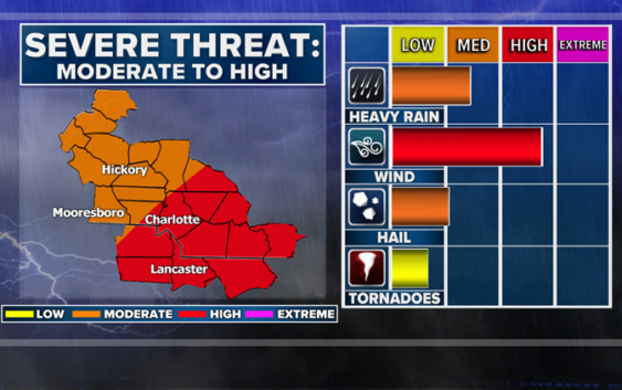
CHARLOTTE, N.C. — The Charlotte area will be bracing for another round potentially severe weather Friday as a large storm system moves into the Carolinas.
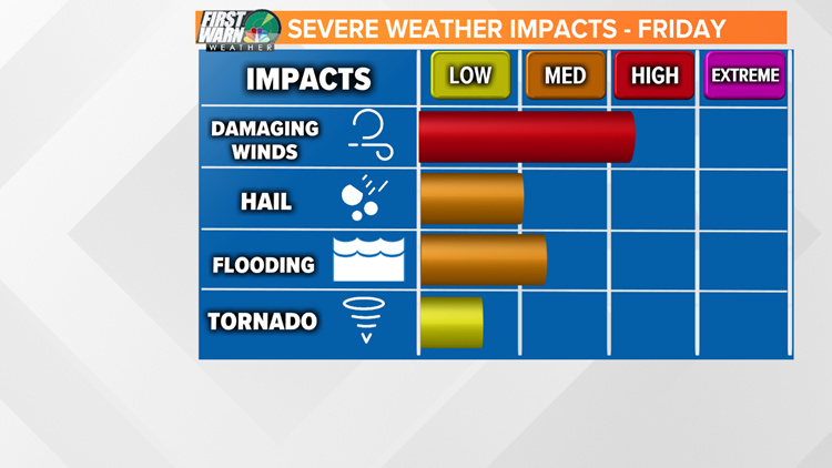
Chief meteorologist Brad Panovich said the storms could bring a threat of hail, flash flooding and isolated tornadoes, depending on the timing. One thing Panovich is confident about is the threat of damaging winds.
“Regardless of what kind of thunderstorms we get, we’re going to see damaging winds, even outside of thunderstorms,” Panovich said.
The National Weather Service has the Charlotte area at a high risk for severe weather potential for Friday.

WCNC
Panovich said the timing could be the difference because if the system slows down, the threat of severe weather in the Charlotte area could increase because of the heat of the day. Currently, the biggest threat for severe weather is east of Charlotte. Panovich said that could lead to the development of supercell storms with rotation.
“The tornado threat could be much higher,” Panovich explained. “If we get some heating and instability to surge in here, the hail and tornado threat could go up in the next 24 hours.”

WCNC
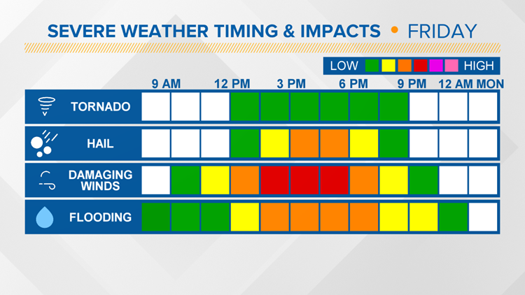
Panovich said the timing for the storms is still a little vague since they’re a full day away but we can expect scattered showers to start around 8 a.m. in the mountains and foothills. By lunchtime, Panovich expects the first line of storms to reach the Piedmont.
“It’ll be crossing over Charlotte around 4 o’clock and there could be some embedded rotation and at the very least some strong wind shear,” Panovich said.

WCNC
First Warn forecaster Larry Sprinkle said some areas south and east of Charlotte could see up to 2 inches of rain, while nearly every area will receive at least a half-inch from the storms. The storms will move out of the Charlotte area Friday night with some leftover sprinkles early Saturday morning.
Saturday will be cooler in the 60s while Easter Sunday will be a beautiful sunny day with afternoon highs in the mid-70s.
POPULAR ON WCNC.COM
CMPD Chief Putney: Only one body camera worked during deadly shooting
Cabarrus County Schools among other districts closed May 1
North Carolina ‘born alive’ abortion bill wins final passage
Girl suspended for kneeing boy in groin who was in girls’ school bathroom
‘Dangerous’ woman ‘infatuated with Columbine shooting’ prompts manhunt