- Seven months after Hurricane Helene, Chimney Rock rebuilds with resilience
- Wildfire in New Jersey Pine Barrens expected to grow before it’s contained, officials say
- Storm damage forces recovery efforts in Lancaster, Chester counties
- Evacuation orders lifted as fast-moving New Jersey wildfire burns
- Heartbreak for NC resident as wildfire reduces lifetime home to ashes
Risk of severe weather increases
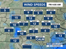
Raleigh, N.C. — The U.S. Storm Prediction Center upgraded the Triangle’s threat for severe weather on Friday to a level 4 of 5.
That means the area is at a moderate risk for severe thunderstorms, particularly in the evening.
“We hardly ever see a risk that’s this high in our area,” meteorologist Elizabeth Garnder said, adding that it’s important to have a severe weather preparedness plan for yourself and your family.
The storm system is expected to come in two waves, Gardner said: one around midday and one in the evening.
Isolated thunderstorms are possible between 10 a.m. and 1 p.m., and the risk for intense storms increases between 3 p.m. and 10 p.m.
The storm system is expected to bring dangerous winds, large hail, downpours and possible tornadoes.
It has already produced tornados, wind damage and hail from Texas to Missouri.
An inch to an inch and a half of rain is expected.