- Seven months after Hurricane Helene, Chimney Rock rebuilds with resilience
- Wildfire in New Jersey Pine Barrens expected to grow before it’s contained, officials say
- Storm damage forces recovery efforts in Lancaster, Chester counties
- Evacuation orders lifted as fast-moving New Jersey wildfire burns
- Heartbreak for NC resident as wildfire reduces lifetime home to ashes
NWS: Severe storms could bring flooding, chance of hail to Hill Country

-
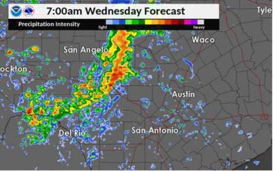
Severe storms are expected in San Antonio on April 24, 2019. Hail is a possibility along with the severe rainfall.
Severe storms are expected in San Antonio on April 24, 2019. Hail is a possibility along with the severe rainfall.
Photo: National Weather Service
Severe storms are expected in San Antonio on April 24, 2019. Hail is a possibility along with the severe rainfall.
Severe storms are expected in San Antonio on April 24, 2019. Hail is a possibility along with the severe rainfall.
Photo: National Weather Service
National Weather Service meteorologists are more confident that severe storms will bring rain and a chance of hail Wednesday in San Antonio, according to the agency’s most recent forecast.
Large hail and damaging straight-line winds remain the primary concern as the storm system develops Tuesday night on the Rio Grande.
FIND OUT FIRST: Get San Antonio breaking news directly to your inbox
Flash floods watches have are in effect Wednesday morning in counties north of San Antonio, including Gillespie, Llano, Burnet, Blanco, Hays Travis and Williamson counties.
This week’s storms are caused by a strong upper-level cold front that is interacting with moisture from the gulf. That will produce thunderstorms across the region.
The rain is expected to fall in San Antonio on Wednesday afternoon through the evening, according to the forecast.
The storm system should pass the region by Thursday morning as it continues east, the forecast showed.
Meteorologists predict that San Antonio may receive up to two inches of rain, with isolated pockets up to 4 inches.
Fares Sabawi covers crime in San Antonio and Bexar County. Read him on our breaking news site, mySA.com, and on our subscriber site, ExpressNews.com | fsabawi@mysa.com|@FaresInSA