- Researchers forecast 1 major Gulf hurricane in 2025 season
- NC State forecasts near-average Atlantic hurricane season
- Timeline: Texas cold front brings hail, heavy rainfall risk to major cities
- Evacuation order issued as crews battle wildfire in McDowell County
- NC Gov. Josh Stein outraged by attack on PA governor, focuses on Hurricane Helene recovery
Flash flood warning for some area counties; New Caney ISD closed Wednesday
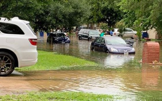
HOUSTON — A flash flood warning is in effect for Harris, Liberty and Montgomery counties until 7:45 p.m. Tuesday. A flash flood warning is also in effect until 8:15 p.m. Tuesday for Fort Bend County.
The Fort Bend County Sheriff’s Office said the Highway 59 northbound feeder at Williams Way is impassable.
Tap here to view a list of high water locations in the Houston area
New Caney ISD will be closed Wednesday due to severe weather.
Some areas have already seen as many as 5 inches of rain and there’s street flooding reported in Kingwood. Houston Police Chief Art Acevedo said the frontage road on Highway 59 North at Northpark is closed due to flooding.
One KHOU 11 viewer shared video of a man in Kingwood whose car took on water as he drove through heavy rain and floodwaters.
There’s also street flooding in Spring. Pedro sent us video of high water near Aldine Westfield.
Jake Smookier shared video of pounding rain in Spring. He said the strong thunderstorm knocked out power in his neighborhood.
There were reports of a possible tornado in Atascocita. KHOU 11 Chief Meteorologist David Paul doesn’t believe it was a tornado and there are no reports of damage in that area.
As of 4:15 p.m., CenterPoint said 22,859 customers are without power.
A strong jet stream overhead combined with a stalled surface frontal boundary plus heavy tropical moisture are the ingredients that can cause flooding in Houston and southeast Texas.
WEATHER RADAR: Track rain & storms across Texas
VIEW CURRENT ALERTS: Tap here for watches & warnings active now
GET ALERTS ON THE GO: Download the KHOU 11 app and follow us on Facebook and Twitter.
More flooding later this week?
As rounds of rain come through and fall on already saturated grounds, more street flooding is likely – especially Friday and Saturday. We’ll just have to watch and wait to see which area watersheds get the most rain and which creeks and bayous threaten to flood. The current forecast calls for rainfall totals of 3 to 4 inches along the coast, 4 to 5 inches in Houston and 5 inches in College Station and Huntsville.
Houston’s Public Works Dept. has already said it will lower the water levels in Lake Houston to prepare for the possibility of heavy rain.
Here’s what to expect this week…
WEATHER TIMELINE:
WEDNESDAY – 30% chance of scattered storms and rain in Houston area, high of 84. Look for mostly cloudy skies and temperatures in the mid 80s both days. Isolated storms can’t be ruled out but it should not be a widespread, all day event.
THURSDAY – 70% chance of storms and rain in Houston area, high of 84. Severe weather possible. High water spots possible due to saturated ground conditions.
FRIDAY – 70% chance of thunderstorms in Houston area, high of 84. High water spots possible due to saturated ground conditions.
SATURDAY- 70% chance for rain on Saturday, high of 82. Rainfall totals expected to be higher in areas north of Houston (College Station into Huntsville).
SUNDAY- 20% rain chance, high of 82 – calmer conditions for Mother’s Day.
ALSO POPULAR ON KHOU.COM: