- Texas’ biggest wildfire started a year ago. How does the Panhandle look now?
- To her, Hurricane Helene debris isn’t trash. It is full of memories — and she’s returning them
- Bills introduced a year after state’s largest blaze seek to limit wildfires
- A year after Texas’ largest wildfire, Panhandle residents tugged between hope and anxiety
- Another $500M for Hurricane Helene relief in North Carolina passes key hurdle
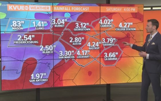
FORECAST: Evening storms; Severe weather threat Wednesday
AUSTIN, Texas — Weather Outlook
A chance for evening showers and storms, especially for areas along and east of IH-35. Strong to severe thunderstorms will be possible Wednesday. Along with the threat of storms producing large hail, damaging winds and tornadoes, heavy downpours could also trigger flash flooding. Chances for scattered showers and storms continue Thursday, Friday & Saturday. Mainly dry Sunday for Mother’s Day.
DETAILED FORECAST:
TUESDAY NIGHT:
Scattered showers and storms possible this evening. Southeast winds from 10 to 15 mph.
LOW: 70°
WEDNESDAY:
Cloudy skies with storms likely. 80% chance for rain. Some storms could be severe and produce heavy downpours. South winds at 10 to 15 mph.
HIGH: 82°
THURSDAY:
Mostly cloudy skies with scattered showers and storms. 70% chance for rain. Some storms could be strong and produce heavy downpours. East to northeast winds at 5 to 15 mph.
HIGH: 80°
RELATED: Allergy Report
Stay with KVUE on social media and download the KVUE News app so you can stay ahead of the storm. kvue.com/app