- Raleigh rethinks how to grow as flooding, heat and traffic worsen
- New legislative panels will investigate ‘facts and circumstances’ of deadly Central Texas floods
- Heavy rain floods downtown Whiteville forcing local businesses to deal with damage again
- New legislative panels will investigate “facts and circumstances” of deadly Central Texas floods
- Springfield Middle School fully reopens next week, a year after devastating EF3 tornado
FORECAST: Flash flood and severe weather threat Wednesday
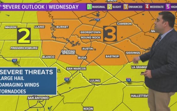
AUSTIN, Texas — Weather Outlook
Strong to severe thunderstorms will be possible Wednesday. Along with the threat of storms producing large hail, damaging winds and tornadoes, heavy downpours could also trigger flash flooding. Chances for scattered showers and storms continue Thursday, Friday & Saturday. Mainly dry Sunday for Mother’s Day.
RELATED: Storm Timeline: When to expect storms Wednesday
DETAILED FORECAST:
WEDNESDAY:
Flash Flood Watch. Cloudy skies with storms likely. 80% chance for rain. Some storms could be severe and produce heavy downpours. South winds at 10 to 15 mph.
HIGH: 82°
WEDNESDAY NIGHT:
Shower or storm possible. A 40% chance of rain. South winds around 5-10 mph.
LOW: 69°
THURSDAY:
Mostly cloudy skies with scattered showers and storms. 60% chance for rain. Some storms could be strong and produce heavy downpours. East to northeast winds at 5 to 15 mph.
HIGH: 82°
RELATED: Allergy Report
Stay with KVUE on social media and download the KVUE News app so you can stay ahead of the storm. kvue.com/app