- Fake job seekers are flooding the market, thanks to AI
- One set of evacuation orders lifted in Caldwell County after wildfire contained
- 'We gutted every building' | Chimney Rock rebuilding after Hurricane Helene
- 'We gutted every building' | Chimney Rock rebuilding after Hurricane Helene
- Debris from Hurricane Helene provides fuel, complicates containment for spring wildfires
Tornado Warning for Cleveland County
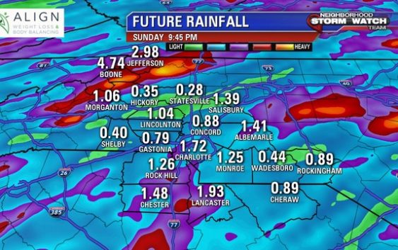
CHARLOTTE, N.C. (FOX 46 CHARLOTTE) – Saturday and Sunday bring chances of severe weather to the Mountains, Foothills, Piedmont, and Sandhills. A stationary frontal boundary is located in the area. This will bring scattered showers and storms.
Saturday morning rain will start off lightly, but will become heavier as the morning progresses. There will be a break in the storm activity from 1-4 p.m.
The second wave of storms will likely be stronger thanks to breaks in the sun and high dew points. Some strong and severe storms are possible from 4-10 p.m. Heavy rain, gusty winds, and hail are possible.
There’s a Slight risk for severe weather on Sunday. On a scale of 1-5, slight risk is a 2. This means scattered strong and severe storms are possible. Similar to Saturday, wind will be a major risk. However, with Friday and Saturday’s rain saturating the soil, flooding may also be an issue on Sunday. With saturated soil and strong winds, downed trees and power lines are possible.
Hail and an isolated tornado can’t be ruled out. Expect the strongest storms between 3-9 p.m.
Download the FOX 46 Weather App for the latest updates from the Neighborhood Storm Watch Team.