- Texas’ biggest wildfire started a year ago. How does the Panhandle look now?
- To her, Hurricane Helene debris isn’t trash. It is full of memories — and she’s returning them
- Bills introduced a year after state’s largest blaze seek to limit wildfires
- A year after Texas’ largest wildfire, Panhandle residents tugged between hope and anxiety
- Another $500M for Hurricane Helene relief in North Carolina passes key hurdle
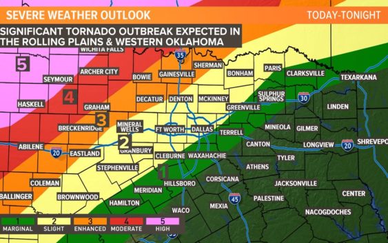
Severe storms, tornadoes possible from N. Texas into Oklahoma

Heads up North Texas! A warm front is lifting north, bringing a surge of moisture into our area. That leaves a small window of time for isolated severe storms for Monday.
A significant severe weather outbreak is expected across Oklahoma and the eastern part of the Texas Panhandle Monday.
If storms form, they would be capable of all modes of severe weather while racing north into Oklahoma.
Otherwise, mostly cloudy skies, windy and warm through late afternoon. Highs climb into the mid-upper 80s with gusty southeast winds of 20-30 mph.
After midnight, widespread storms are expected to move through with damaging winds and heavy rain threat for the morning commute. Storms move east by midday with a damaging wind and hail threat for areas east of DFW during the afternoon on Tuesday. Quiet weather and warm temperatures are expected for the rest of the week.
TODAY: Scattered storms possible this afternoon (40%), mostly cloudy, windy & warm. Winds: S 20-30. High: 86.
TONIGHT: Storms possible after midnight. (50%). Winds: SE 15-25. Low: 70.
TUESDAY: Storms likely in the morning (70%). Winds: SW 15-25. High: 82.
Remember to download the WFAA app to check one of our dozens of local radars near you as well as the latest forecast, cameras and current conditions.
Check Weather Alerts here.