- Fake job seekers are flooding the market, thanks to AI
- One set of evacuation orders lifted in Caldwell County after wildfire contained
- 'We gutted every building' | Chimney Rock rebuilding after Hurricane Helene
- 'We gutted every building' | Chimney Rock rebuilding after Hurricane Helene
- Debris from Hurricane Helene provides fuel, complicates containment for spring wildfires
Severe weather begins to move out of Triangle
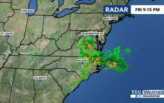
Raleigh, N.C. — Severe weather was moving out of the area Friday night after a line of storms brought hail, rain and winds to much of central North Carolina earlier this evening.
Large hail was reported in Apex and Edgecombe County, some of it damaging cars and windshields, according to social media posts.
WRAL meteorologist Kat Campbell said clearing was beginning from the west, and Orange County was removed from the severe weather threat.
But she said Johnston, Wayne and Wilson remained under a severe weather warning for several more hours.
As of 8 p.m., much of the Triangle was under a severe thunderstorm watch until 11 p.m.
Some parts of the county were under a severe thunderstorm warning that extend through 8 p.m. or 8:30 p.m.
Wind gusts were reported between 40 and 50 miles per hour.
The threat of severe weather Friday comes on the heels of stray storms that popped up around areas south of Fayetteville, which saw reports of downed trees and damaged buildings after storms Thursday night.

There’s a 30 percent chance of rain on Saturday as Friday’s cold front stalls. The high will be 87 degrees.
Sunday has another 30 percent chance of rain, with temperatures reaching 88 degrees.
Temperatures are expected to stay in the 80s next week.
