- McDowell County wildfire spreads to 500 acres, evacuation orders in place
- Evacuations in Caldwell County due to wildfire
- Northwest Houston 'ghost neighborhood' caused by repeated flooding to become latest detention basin
- NHL playoffs: Hurricanes open playoffs Easter Sunday afternoon vs. Devils
- 2 wildfires spreading in rugged terrain in western North Carolina
Severe weather moves out of central NC
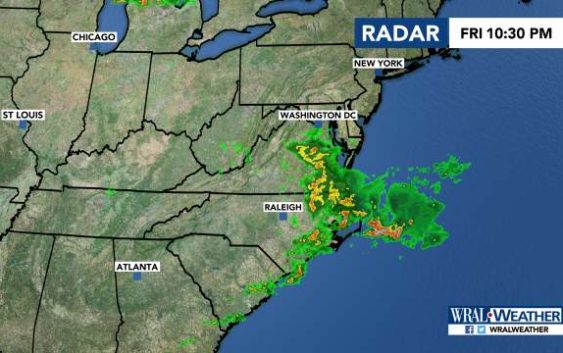
Raleigh, N.C. — Severe weather was moving out of the area Friday night after a line of storms brought hail, rain and winds to much of central North Carolina earlier in the evening.
Large hail was reported in Apex and Edgecombe County, some of it damaging cars and windshields, according to social media posts.
WRAL meteorologist Kat Campbell said as of 10:30 p.m., almost all of the viewing area was cleared from the severe thunderstorm watch.
The severe weather resulted in several last minute schedule changes to sports games being played throughout the Triangle. And wind gusts were reported between 40 and 50 miles per hour.
The threat of severe weather Friday comes on the heels of stray storms that popped up around areas south of Fayetteville, which saw reports of downed trees and damaged buildings after storms Thursday night.

There’s a 30 percent chance of rain on Saturday as Friday’s cold front stalls. The high will be 87 degrees.
Sunday has another 30 percent chance of rain, with temperatures reaching 88 degrees.
Temperatures are expected to stay in the 80s next week.
