- National memorial to honor NC firefighter who died on duty during Hurricane Helene
- Gov. Josh Stein extends State of Emergency for western NC wildfires
- Governor Stein extends state of emergency for NC wildfire threat
- Governor Stein extends emergency in 34 NC counties amid wildfire threat
- Texans can buy emergency preparation supplies tax-free April 26-28 ahead of severe weather season
Gulf weather update: Flash Flood Watch goes into effect late tonight

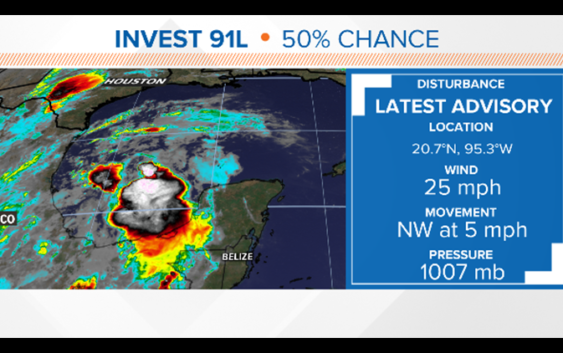
A tropical disturbance will cross the far Southern Gulf of Mexico and head towards Mexico.
As of Tuesday morning the Hurricane Center gives the system a 50 percent chance of developing over the next two days. But even if it doesn’t become a named storm, it will send a surge of deep tropical moisture into Texas.

khou
Flash Flood Watch for all of Houston
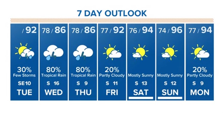
Severe conditions are not expected, but the disturbance will likely bring heavy rain to our area – especially on Wednesday and Thursday.
VIEW CURRENT ALERTS: Tap here for watches & warnings active now
WEATHER RADAR: Track rain & storms across Texas
GET ALERTS ON THE GO: Download the KHOU 11 app and follow us on Facebook and Twitter.
A Flash Flood Watch goes into effect late Tuesday night until Thursday morning for all of Southeast Texas, impacting these counties/areas: Austin; Brazoria Islands; Brazos; Burleson; Chambers; Coastal Brazoria; Coastal Galveston; Coastal Harris; Coastal Jackson; Coastal Matagorda; Colorado; Fort Bend; Galveston Island and Bolivar Peninsula; Grimes; Houston; Inland Brazoria; Inland Galveston; Inland Harris; Inland Jackson; Inland Matagorda; Madison; Matagorda Islands; Montgomery; Northern Liberty; Polk; San Jacinto; Southern Liberty; Trinity; Walker; Waller; Washington; Wharton.
Both Wednesday and Thursday there is an 80-percent rain chance. Some areas could receive six inches or more of rain that could lead to flash street flooding. Wednesday afternoon through Thursday morning is especially when you’ll want to watch for the possibility of flooded streets in Southeast Texas, warns KHOU 11 Meteorologist Chita Craft.


KHOU
We know the onset of heavy rain is almost certain. As with any tropical system, rainfall will be prolific and will be blinding at times. Rainfall rates will be efficient, falling at a rate as high as 2 to 3 inches per hour, especially as the system makes its closest approach to our area on Thursday.
The National Weather Service here in Houston is saying flooding will be a considerable risk for some, especially in the southwest areas of southeast Texas, mainly south of I-10.
While many of us will see a a few inches of rain, there could be some small isolated areas where rainfall rates tally considerably more than that.
Heavy rain is the only threat at this time. No severe weather is expected to accompany Invest 91-L as it passes by our area.
In a nutshell:
-Rain chances increase beginning Tuesday.
-Heavy rain will begin throughout the Houston area, especially Wednesday afternoon, evening and night.
-Rainfall rates could be high in some locations on Thursday as the system makes its closest approach to Houston. Some areas could pick up “considerable” amounts of rain.
-This system, even if it does develop into a tropical storm, will have the same impacts on Texas: rain and some flooding. Nothing more.
-This forecast remains in flux so stay close to khou.com for the very latest on this developing weather situation.
BE PREPARED THIS HURRICANE SEASON
Items that should be on your hurricane preparation list if a storm heads our way:
- Water – at least 1 gallon daily per person for 3-7 days; also fill the bathtub and other containers; sports drinks are good to fend off dehydration
- Food – at least enough for 3-7 days; non-perishable packaged or canned food; juices; foods for infants or elderly family members; snack foods; food for special diets
- Non-electric can opener
- Cooking tools, fuel
- Paper plates and cups, plastic utensils
- Bedding: blankets, pillows, etc.
- Clothing
- Rain gear
- Sturdy shoes
- First aid kit, medicines, prescription drugs
- Toiletries, hygiene items, moisture wipes, dry shampoo
- Flashlight, batteries, lanterns
- Radio: Battery operated and NOAA weather radio
- Telephones: Fully charged cell phone with extra battery; chargers; traditional (not cordless) telephone set
- Cash (with some small bills) and credit cards: Banks and ATMs may not be available for extended periods
- Important documents: Place in a waterproof container or watertight resealable plastic bag: Should include insurance, medical records, bank account numbers, Social Security card, prescriptions, etc.
- Tools: Keep a set with you during the storm
- Gas: Fill up your vehicles several days before landfall is expected; Gas stations could lose power during a storm and supply trucks may not be able to reach the area
- Pet care items: Proper identification, immunization records, medications, ample supply of food and water; a carrier or cage; muzzle and/ or leash
- Bleach without lemon or any other additives
- Fire extinguisher
- Mosquito repellent
- Keys
- Toys, books and games for children
- Duct tape
- Cell phone charging stations — locations where you can charge mobile devices
RELATED: Do you have your KHOU 11 severe weather guide?
RELATED: If storms give you anxiety, therapy is available online