- Hays County judge says software glitch caused some communication issues during wildfires
- FEMA deadline for Hurricane Helene recovery aid to governments, nonprofits extended
- Sellers and Rantanen are among the NHL trade deadline winners. Hurricanes and Boeser are some losers
- Hurricane forecasters express concern over NOAA job cuts impact
- FEMA deadline for Hurricane Helene recovery aid extended again
FORECAST: Severe weather threat Thursday
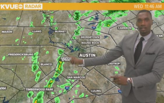
AUSTIN, Texas — Weather Outlook
An isolated lingering shower is possible this evening. Partly cloudy skies tonight with patchy fog and drizzle developing after midnight. A front will move into the area tomorrow afternoon allowing for scattered thunderstorms to develop. A few storms could be strong or severe, with large hail and damaging winds being the primary threats. Dangerous heat this weekend with surface temperatures in the upper 90s and heat index values at or above 105 degrees.
RELATED: Severe storms possible Thursday afternoon in Central Texas
DETAILED FORECAST:
TONIGHT:
A 20% chance of an isolated lingering shower this evening; partly cloudy skies later tonight. East wind shifting to the southwest at 5 mph.
LOW: 74°
TOMORROW:
Patchy morning fog. Mostly cloudy skies with a 60% chance of showers and thunderstorms, some could be strong or severe. Northwest wind 5 to 10 mph.
HIGH: 91°
FRIDAY:
Mix of clouds and sun with a 20% chance of an isolated shower. Hot and humid with temperatures in the mid-90s. Northwest wind 5 to 10 mph.
HIGH: 96°
RELATED: Allergy Report
Stay with KVUE on social media and download the KVUE News app so you can stay ahead of the storm. kvue.com/app