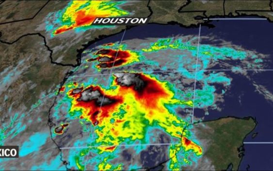
Gulf weather timeline: Flash Flood Watch for Houston area in effect

Heavy, widespread rain is expected to hit the Houston area Wednesday.
As of Tuesday night, the Hurricane Center said the chances of the area of low pressure in the Gulf developing into a tropical storm are now considered remote.
As we’ve said all along, there are no changes to the forecast regarding what to expect. However, there have been changes to the timing. Please see below.
VIEW CURRENT ALERTS: Tap here for watches & warnings active now
WEATHER RADAR: Track rain & storms across Texas
GET ALERTS ON THE GO: Download the KHOU 11 app and follow us on Facebook and Twitter.
Flash Flood Watch for all of Houston
Severe conditions are not expected, but the disturbance will likely bring heavy rain to our area – especially on Wednesday and Thursday.
A Flash Flood Watch goes into effect late Tuesday night until Thursday morning for all of Southeast Texas, impacting these counties/areas: Austin; Brazoria Islands; Brazos; Burleson; Chambers; Coastal Brazoria; Coastal Galveston; Coastal Harris; Coastal Jackson; Coastal Matagorda; Colorado; Fort Bend; Galveston Island and Bolivar Peninsula; Grimes; Houston; Inland Brazoria; Inland Galveston; Inland Harris; Inland Jackson; Inland Matagorda; Madison; Matagorda Islands; Montgomery; Northern Liberty; Polk; San Jacinto; Southern Liberty; Trinity; Walker; Waller; Washington; Wharton.
Weather Timeline
There has been a change to the timing regarding the rains arrival and departure. Please see below for details.
WEDNESDAY: The morning commute will be a disaster. Plan ahead! Expect a washout with the possibility of street flooding. Rain chances stand at 100 percent as very deep tropical moisture associated with Invest 91-L moves through the area.
The National Weather Service is saying that rainfall rates will be approaching 3 inches per hour with as much as 6 inches in a four-hour window. If those rain rates are realized and come to fruition, widespread street flooding will be an issue.
We know everybody wants to know exactly how much rain they can expect in their town or neighborhood but that’s impossible. Just know that widespread 2-4 inches of rain is expected with isolated pockets considerably higher. Some models are even advertising as much as 8 to 10 inches.
The good news here is that the storm speeds should be fast — meaning they won’t be sitting over any one area for too long. Unfortunately, as with any tropical disturbance, the rain pushes through band after band after band. So while the storms themselves will be moving fast, they’ll be replaced by more rain as the feederbands continue to stream through.
Aside from the heavy rain, we’ll have to watch for the possibility of funnel clouds and quick, weak tornadoes although severe weather is not expected to be a big problem.
THURSDAY: Rain chance decreases after the early-morning hours — after 4 a.m. — but scattered showers will linger into the mid-morning hours. Drier conditions after lunchtime as the center of circulation pushes through.
FRIDAY: 20-percent rain chance remains as the temperatures begin to soar. Expect temps back into the low 90s with feels-like numbers approaching 100°F.
THIS WEEKEND: Mostly sunny- hottest temperatures of the year so far, topping out in the mid- to upper-90s. Feels-like numbers could top 105°F or higher. You’ll certainly want to practice heat safety which means drinking lots of water, staying in the shade and wearing light colored clothing.
Come on Houston, we know how to ‘Summer’ around here. Be smart and take care of yourself. You don’t need me preaching to ya!
BE PREPARED THIS HURRICANE SEASON
Items that should be on your hurricane preparation list if a storm heads our way:
- Water – at least 1 gallon daily per person for 3-7 days; also fill the bathtub and other containers; sports drinks are good to fend off dehydration
- Food – at least enough for 3-7 days; non-perishable packaged or canned food; juices; foods for infants or elderly family members; snack foods; food for special diets
- Non-electric can opener
- Cooking tools, fuel
- Paper plates and cups, plastic utensils
- Bedding: blankets, pillows, etc.
- Clothing
- Rain gear
- Sturdy shoes
- First aid kit, medicines, prescription drugs
- Toiletries, hygiene items, moisture wipes, dry shampoo
- Flashlight, batteries, lanterns
- Radio: Battery operated and NOAA weather radio
- Telephones: Fully charged cell phone with extra battery; chargers; traditional (not cordless) telephone set
- Cash (with some small bills) and credit cards: Banks and ATMs may not be available for extended periods
- Important documents: Place in a waterproof container or watertight resealable plastic bag: Should include insurance, medical records, bank account numbers, Social Security card, prescriptions, etc.
- Tools: Keep a set with you during the storm
- Gas: Fill up your vehicles several days before landfall is expected; Gas stations could lose power during a storm and supply trucks may not be able to reach the area
- Pet care items: Proper identification, immunization records, medications, ample supply of food and water; a carrier or cage; muzzle and/ or leash
- Bleach without lemon or any other additives
- Fire extinguisher
- Mosquito repellent
- Keys
- Toys, books and games for children
- Duct tape
- Cell phone charging stations — locations where you can charge mobile devices
RELATED: Do you have your KHOU 11 severe weather guide?
RELATED: If storms give you anxiety, therapy is available online