- Debris from Hurricane Helene provides fuel, complicates containment for spring wildfires
- David & Nicole Tepper increase Hurricane Helene relief commitment to $750k
- David & Nicole Tepper increase Hurricane Helene relief commitment to $750k
- McDowell County wildfire spreads to 500 acres, evacuation orders in place
- Evacuations in Caldwell County due to wildfire
Watch Live: Heavy rain moving into Houston from the southwest | Flash Flood Warning

HOUSTON — Heavy, widespread rain is moving into parts of Southeast Texas and the Houston area now due to a disturbance in the Gulf of Mexico.
>> The 9:20 a.m. live news, traffic and weather update will stream live in the video player above
A Flash Flood Watch continues for all of Southeast Texas, including Houston, until Thursday morning.
A Flash Food Warning is currently in effect for Austin, Brazoria, Fort Bend, Matagorda, Jackson and Wharton counties until 9:45 a.m. – although Chita says the greatest flood threat is primarily in Wharton County and only a very small portion of Fort Bend.
As of 8:48 a.m. the Wharton County Office of Emergency Management said some parts of their area already received up to 11 inches of rain, although there are no reports of water getting into homes. Courts are delayed until 10 a.m.
HIGH WATER LIST: Current high water locations on major roads
TRAFFIC: List of incidents/crashes
VIEW CURRENT ALERTS: Tap here for watches & warnings active now
WEATHER RADAR: Track rain & storms across Texas
GET ALERTS ON THE GO: Download the KHOU 11 app and follow us on Facebook and Twitter.
Timeline: What to expect after this morning
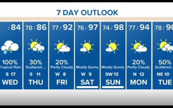
WEDNESDAY MORNING: The morning commute will be wet. Expect a washout with the possibility of street flooding through lunchtime. Rain chances stand at 100 percent as very deep tropical moisture associated with Invest 91-L moves through the area. Aside from the heavy rain, we’ll have to watch for the possibility of funnel clouds and quick, weak tornadoes although severe weather is not expected to be a big problem.
WEDNESDAY AFTERNOON/EVENING: Significant rain chance continues until the late afternoon, so your drive home will likely be wet as well. KHOU 11 Meteorologist Chita Craft says this afternoon’s rain threat will be greater along the coast where some spots could get 10 inches of rain. After 6 p.m. the rain chance greatly decreases, but don’t let your guard down as there’s still a chance for isolated downpours and storms.
THURSDAY: 30 percent rain chance. Another wet morning commute but the rain won’t be as heavy as Wednesday’s. Rain chance decreases after the early-morning hours, but scattered showers will linger into the mid-morning hours. Drier conditions after lunchtime as the center of circulation pushes through.

7-day forecast
KHOU 11
FRIDAY: 20 percent rain chance remains as the temperatures begin to soar. Expect temps back into the low 90s with feels-like numbers approaching 100°F.
THIS WEEKEND: Mostly sunny- hottest temperatures of the year so far, topping out in the mid- to upper-90s. Feels-like numbers could top 105°F or higher. You’ll certainly want to practice heat safety which means drinking lots of water, staying in the shade and wearing light colored clothing.
BE PREPARED THIS HURRICANE SEASON
Items that should be on your hurricane preparation list if a storm heads our way:
- Water – at least 1 gallon daily per person for 3-7 days; also fill the bathtub and other containers; sports drinks are good to fend off dehydration
- Food – at least enough for 3-7 days; non-perishable packaged or canned food; juices; foods for infants or elderly family members; snack foods; food for special diets
- Non-electric can opener
- Cooking tools, fuel
- Paper plates and cups, plastic utensils
- Bedding: blankets, pillows, etc.
- Clothing
- Rain gear
- Sturdy shoes
- First aid kit, medicines, prescription drugs
- Toiletries, hygiene items, moisture wipes, dry shampoo
- Flashlight, batteries, lanterns
- Radio: Battery operated and NOAA weather radio
- Telephones: Fully charged cell phone with extra battery; chargers; traditional (not cordless) telephone set
- Cash (with some small bills) and credit cards: Banks and ATMs may not be available for extended periods
- Important documents: Place in a waterproof container or watertight resealable plastic bag: Should include insurance, medical records, bank account numbers, Social Security card, prescriptions, etc.
- Tools: Keep a set with you during the storm
- Gas: Fill up your vehicles several days before landfall is expected; Gas stations could lose power during a storm and supply trucks may not be able to reach the area
- Pet care items: Proper identification, immunization records, medications, ample supply of food and water; a carrier or cage; muzzle and/ or leash
- Bleach without lemon or any other additives
- Fire extinguisher
- Mosquito repellent
- Keys
- Toys, books and games for children
- Duct tape
- Cell phone charging stations — locations where you can charge mobile devices
RELATED: Do you have your KHOU 11 severe weather guide?
RELATED: If storms give you anxiety, therapy is available online