- Seven months after Hurricane Helene, Chimney Rock rebuilds with resilience
- Wildfire in New Jersey Pine Barrens expected to grow before it’s contained, officials say
- Storm damage forces recovery efforts in Lancaster, Chester counties
- Evacuation orders lifted as fast-moving New Jersey wildfire burns
- Heartbreak for NC resident as wildfire reduces lifetime home to ashes
No, That Wasn't a Tornado That Touched Down in San Antonio, the Weather Service Reports
click to enlarge
- Twitter / @MaxMasseyTV
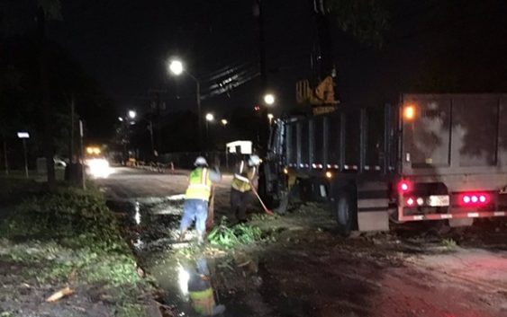
- A cleanup crew removes debris from a roadway following Thursday’s thunderstorm.
Parts of San Antonio may look like a tornado whipped through Thursday evening, but the National Weather Service attributed the damage to straight line winds.
“Based on radar data, we don’t suspect that there was any tornadic activity with the storms that rolled through San Antonio Thursday, just very intense straight line winds in excess of 50 miles an hour,” NWS meteorologist Ethan Williams told KSAT-12.
The storm, which struck during rush hour, downed power lines and scattered tree limbs, trash cans and fallen traffic lights across local roads. Thousands are still without power at press time Friday, according to CPS Energy’s online outage map.
While some residents posted social media photos of clouds that resembled tornados, Williams told KSAT the formations were most likely rapidly condensing air being lifted before the storm’s onset.
Firefighters received some 478 service calls during the storm, according to a MySanAntonio report. Those calls included 133 responses to downed power lines, three fires caused by lightning strikes and one water rescue.
Stay on top of San Antonio news and views. Sign up for our Weekly Headlines Newsletter.