- Sellers and Rantanen are among the NHL trade deadline winners. Hurricanes and Boeser are some losers
- Hurricane forecasters express concern over NOAA job cuts impact
- FEMA deadline for Hurricane Helene recovery aid extended again
- Tornado drills to take place at schools across North Carolina Friday morning
- Hays County emergency alerts cause confusion during Tuesday's wildfires
Flash flood warning issued in parts of north central NC
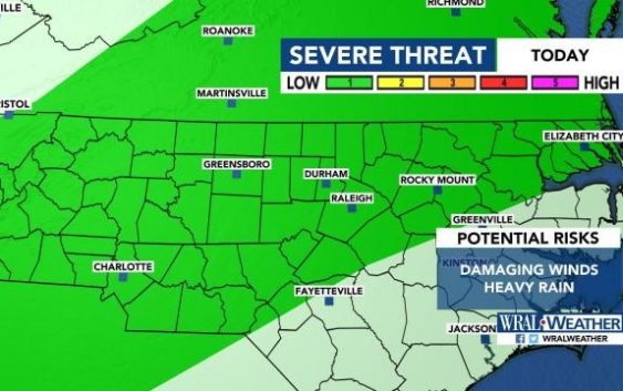
Raleigh, N.C. — A flash flood warning was issued for Vance, Durham, Granville, Orange and Person counties until 2 a.m. Wednesday as heavy rain fell.
The National Weather Service reported that 3 to 4 inches of rain had fallen in some areas by 10:45 p.m. Tuesday.
Much of the viewing area, including the Triangle northward, was under a level 1 risk for severe weather throughout the day.
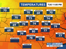
The rain will die down early Wednesday, WRAL meteorologist Mike Maze said, but there’s a 50% chance for rain in the afternoon and evening.
Wednesday’s high is expected to be 87 degrees.
Thursday will be drier and hotter, Maze said, but there’s another 50% chance rain on Thursday evening and Thursday night. Some of that weather could be severe.
Thursday’s temperatures will reach the mid-90s.
Friday, the first day of summer, will be the first chance at a clear day this week, with sunny skies and a high in the upper 80s.

Heat and the chance for scattered storms will last throughout the weekend and into next week.