- National memorial to honor NC firefighter who died on duty during Hurricane Helene
- Gov. Josh Stein extends State of Emergency for western NC wildfires
- Governor Stein extends state of emergency for NC wildfire threat
- Governor Stein extends emergency in 34 NC counties amid wildfire threat
- Texans can buy emergency preparation supplies tax-free April 26-28 ahead of severe weather season
Storms, damaging winds, to push into Charlotte
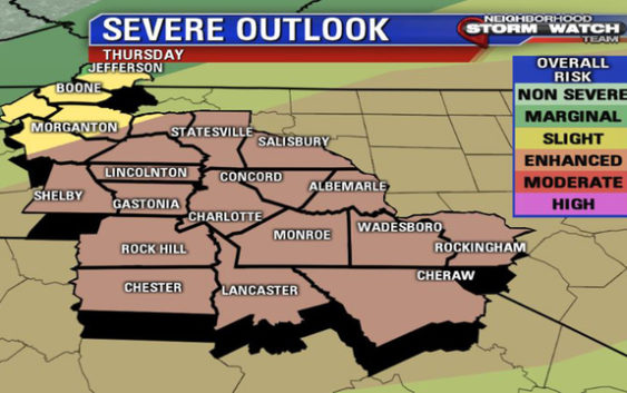
(FOX 46 CHARLOTTE) – A cold front will swing through Thursday and fire up strong to severe storms this afternoon and evening. The storms will start developing between the hours of 3 p.m. and 5 p.m. and race eastward across the FOX 46 Charlotte viewing area until sunset.
Damaging winds and hail will be the main concerns and to a lesser extent heavy rain with a slim tornado threat as well.
The better chances for any tornadic development will likely be east of I-77 where there will be more unstable air.
The piedmont of the viewing area is under an enhanced risk for severe weather which means there will be numerous severe storms that will be persistent and intense.
The mountains and foothills are under a slight risk for severe weather which is lower on the risk scale.
A slight risk means there will be scattered storms that will be isolated but intense. By 8 p.m. most of the storms should be out of the FOX 46 viewing area.
Stay weather aware today and arm yourself by downloading the FOX 46 weather app.