- Texas’ biggest wildfire started a year ago. How does the Panhandle look now?
- To her, Hurricane Helene debris isn’t trash. It is full of memories — and she’s returning them
- Bills introduced a year after state’s largest blaze seek to limit wildfires
- A year after Texas’ largest wildfire, Panhandle residents tugged between hope and anxiety
- Another $500M for Hurricane Helene relief in North Carolina passes key hurdle
Tropical update: Houston on edge of latest forecast cone | Part of Louisiana under Hurricane Watch
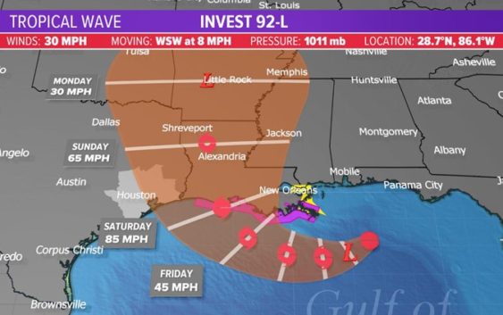
HOUSTON — The KHOU 11 Weather Team continues to monitor the tropical disturbance in the Gulf of Mexico. The National Hurricane Center’s 3:40 p.m. update on Wednesday issued the second cone of uncertainty for the disturbance:

KHOU
Latest Advisory:
A Hurricane Watch has been issued for the central Louisiana coastline. The cone issued at 3:40 p.m. Wednesday shifted slightly right, putting Houston right on the edge.
New Information:
• The hurricane reconnaissance plane is in the air and currently investigating the stystem.
• Hurricane watch may be issued for the upper-Texas coast, that may include Houston/Galveston, as early as tonight.
At this time there are no watches or warnings anywhere along the Texas coast or even the western Louisiana coast, although portions of the coast near New Orleans are now under a Tropical Storm Watch and a Storm Surge Watch. Texas is still within the cone of uncertainty, however, which means we can’t let our guard down yet.
RELATED: Tornado warnings, flooding reported in New Orleans area ahead of Gulf disturbance
What We Know:
- NHC has increased the probability of development to 100%
- The disturbance moved into the Gulf of Mexico
- Hurricane recon plane is in the air
- We should have a better forecast track Wednesday afternoon
- It’s important to understand the uncertainty – the models could shift back to Texas just as easily as they shifted to Louisiana
- If Houston ends up on the western side of the system, we will be on the “dry side” if Houston ends up with a direct hit or on the eastern side of the system, we will be on the “wet side” and can expect more rain and wind.
- Continue to review your hurricane supplies and become familiar with what evacuation zone you’re in and what route you’ll take in the event one is called.
LINKS YOU CAN USE:
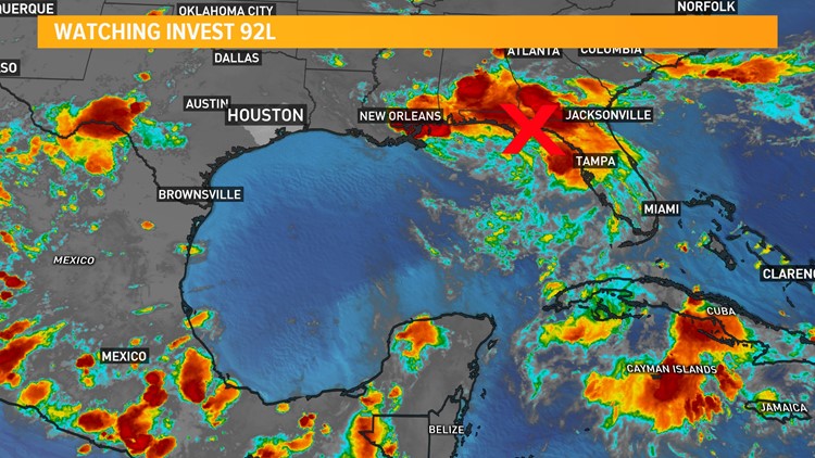
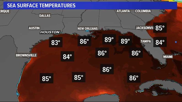
The system has moved out over the warm waters (almost 90 degrees) of the northern Gulf, and thunderstorm activity has increased.
Surface pressures are expected to begin to fall and a low pressure center is expected to form in the next 36 hours.

KHOU
Where the storm ends up and how close it gets to the Texas coast will have huge implications on our forecast for the weekend.
If the center of the storm stays to the east of Houston, we could end up with a hot dry weekend.
A shift to the west and closer to Houston would be more likely to bring more wind and rain. That’s why getting data back from Wednesday’s Hurricane Hunter flight is so important.
Everybody wants to know how strong this storm could be and the answer is that all possibilities exist from a weak tropical storm to a strong hurricane. The gulf is ripe for development with water temps in the upper 80s and a very low wind-shear environment.

KHOU
What we don’t know:
- We don’t know what stretch of coast will be impacted. It’s still too early.
- We don’t know how strong this system could be. All categories are on the table.
- We don’t know how the weekend forecast for Houston will transpire. Everything from hot and dry to hurricane conditions are possible. The forecast will continue to be ever changing, almost by the hour.
What do you need to do?
- Make sure you check on the weather at least twice a day; once in the morning and once in the evening.
- Check your hurricane supply kits. Make sure you’re ready in the event we get a storm, which at this time remains very uncertain.
- Go over your storm plan with your family. Where would you go? What route would you take if asked to evacuate?
- Stay informed. Check in with us twice a day. Once in the morning and once before you go to bed so you don’t get caught off guard.
CLICK HERE FOR THE RED CROSS HURRICANE SAFETY CHECKLIST.
What are high pressure cells?
Steering currents will be the drivers for the forecast come Friday and Saturday here locally.
Think of high pressure cells as bumpers. Hurricanes, as ferocious as they are, are lazy and don’t put up a fight with high pressure. They just go as they are told so-to-speak. As long as a high is over you, you’re good. The area of high pressure that was centered over us is backing westward and that will allow a small opening for a big moisture source.
For the latest updates on Invest 92L, click here or watch playlist below.