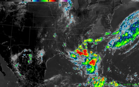
See how the potential hurricane in the Gulf is forming

-
Satellite images from the National Weather Service show the storm as of 2 p.m. Tuesday, July 9. The red colors indicate colder cloud temperatures. That means the clouds are higher in the atmosphere, which indicates thunderstorms.
>>> See more satellite images
Satellite images from the National Weather Service show the storm as of 2 p.m. Tuesday, July 9. The red colors indicate colder cloud temperatures. That means the clouds are higher in the atmosphere, which … morePhoto: National Weather Service
>>> See more satellite images
Photo: National Weather Service
Houston is now out of the trajectory predictions for what could become the first named hurricane of the season, according to forecasters.
The system currently looming over the northern Gulf is expected to make landfall on the southern coast of Louisiana this weekend.
See how the potential hurricane is developing in the gallery above, according to National Weather Service satellite images.
Right now, the system has maximum sustained winds of 30 mph, according to the National Hurricane Center. It’s is expected to gather strength today as a tropical depression, which involve wind speeds of at least 39 mph. It could become a weak hurricane on Friday, according to earlier reports.
A recon flight is expected to investigate the weather system Thursday afternoon to get more information about its potential strength.
Outer bands of rain may still impact the Houston area. The forecast shows a 30 to 40 percent of thunderstorms from today until Monday.
Julian Gill is a digital reporter in Houston. Read him on our breaking news site, Chron.com, and on our subscriber site, houstonchronicle.com. | julian.gill@chron.com | NEWS WHEN YOU NEED IT: Text CHRON to 77453 to receive breaking news alerts by text message | Sign up for breaking news alerts delivered to your email here.
STAY AHEAD OF BAD WEATHER: Text STORMS to 77453 to get breaking weather text alerts| Sign up to receive breaking news alerts delivered to your email here.