- Texas’ biggest wildfire started a year ago. How does the Panhandle look now?
- To her, Hurricane Helene debris isn’t trash. It is full of memories — and she’s returning them
- Bills introduced a year after state’s largest blaze seek to limit wildfires
- A year after Texas’ largest wildfire, Panhandle residents tugged between hope and anxiety
- Another $500M for Hurricane Helene relief in North Carolina passes key hurdle
Soon-to-Be Tropical Storm Barry on a Path for Louisiana

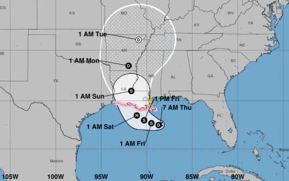
The disturbance labeled Potential Tropical Cyclone Two (eventually Tropical Storm, perhaps Hurricane, Barry) spent overnight Wednesday stumbling around the north central Gulf of Mexico remaining a rather disorganized blob.
Forecast models, which had begun trending eastward in forecast tracks yesterday continued that overnight, some even putting a bulls-eye on the New Orleans area, which has already seen more than 10 inches of rain from the broad mess of rain and storms surrounding the surface low pressure over water.
The National Hurricane Center still believes this will become Tropical Storm and eventually Hurricane Barry before landfall. It should be only a modest category 1 storm with winds around 75-85 mph near the center, but the primary threat from this storm is rain, lots of it.
Precipitation forecasting is calling for 15-20 inches of rain to fall along the path and east of the storm with spots reaching as high as 30 inches. Areas from central to eastern Louisiana may be in the direct path of the storm, but the effects will be felt into Mississippi, Alabama and, ultimately, north into Arkansas and the Mississippi Valley.
Any storm surge, however modest, will also push water back up the Mississippi River further exacerbating flooding issues. While currently it appears the levee system around New Orleans should be tall enough to handle the rainfall and surge, water could top the levees in places that have not been increased in height since Hurricane Katrina in 2005.
For Houston and east Texas, we are on the dry side of the storm meaning increased heat and decreased humidity. North winds from the back side of the storm should dry us out and cause temperatures over the weekend to inch towards triple digits. There is a slight chance of a stray storm or two on Saturday and Sunday, but if the storm does indeed move farther east, that may be wishful thinking. For now, we should be sunny and hot while our neighbors to the east will be quite the opposite.