- Report: Coastal flooding could threaten 1.4 million homes by midcentury
- Caught on camera | Tornado touches down in Missouri
- Carolina Hurricanes playoff tickets go on sale next week
- Storms kill 6 in the South and Midwest as forecasters warn of catastrophic rains, floods this week
- Weather Impact Alert: Cold front could trigger severe weather in Houston area this weekend | See timeline
Tropical storm Barry forms in Gulf: Expected to become hurricane before landfall

HOUSTON — The KHOU 11 Weather Team continues to monitor the tropical disturbance in the Gulf of Mexico.
In its 10 a.m. update The National Hurricane Center just upgraded the system to a tropical storm, but it will likely strengthen to a tropical storm and then a Cat. 1 hurricane by the time it makes landfall.
RELATED: Houston Forecast: Increasing rain chance Thursday and Friday
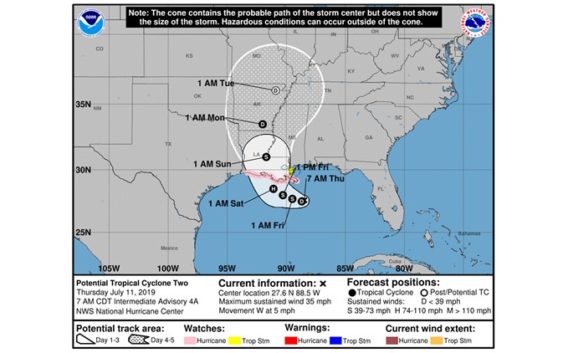
Here is the latest cone of uncertainty for Tropical Storm Barry, which shows the Texas Coast is no longer in the forecast track:

NHC update at 7 a.m. Thursday
NHC
What’s the difference between a tropical depression and a tropical storm?
“A tropical depression forms when a low pressure area is accompanied by thunderstorms that produce a circular wind flow with maximum sustained winds below 39 mph. An upgrade to a tropical storm occurs when cyclonic circulation becomes more organized and maximum sustained winds gust between 39 mph and 73 mph.”
There are currently no watches or warnings for the Texas coast. Texas is on the “dry side” of this system, but we are still expecting scattered rain and storms in Houston starting Thursday and lasting through the weekend.
10 a.m. Thursday Advisory:
A Hurricane Watch has been issued for nearly all of the Louisiana coastline. Max sustained winds are 35 mph with the system moving west at 5 mph.
New Information:
- A second hurricane hunter has just completed a pass through the system
- A low level spin may be taking shape and the system could be upgraded to a tropical depression or tropical storm early Thursday
- At this time there are no watches or warnings anywhere along the Texas coast although portions of the coast near New Orleans are now under a Tropical Storm Watch and a Storm Surge Watch.
- Texas is still within the cone of uncertainty, however, which means we can’t let our guard down yet.
RELATED: Tornado warnings, flooding reported in New Orleans area ahead of Gulf disturbance
What We Know:
- NHC has increased the probability of development to 100%
- The disturbance moved into the Gulf of Mexico
- Hurricane recon plane is in the air
- We should have a better forecast track Thursday morning
- It’s important to understand the uncertainty – the models could shift back to Texas just as easily as they shifted to Louisiana
- If Houston ends up on the western side of the system, we will be on the “dry side” if Houston ends up with a direct hit or on the eastern side of the system, we will be on the “wet side” and can expect more rain and wind.
- Continue to review your hurricane supplies and become familiar with what evacuation zone you’re in and what route you’ll take in the event one is called.
LINKS YOU CAN USE:
Where the storm ends up and how close it gets to the Texas coast will have huge implications on our forecast for the weekend.
If the center of the storm stays to the east of Houston, we could end up with a hot dry weekend.
A shift to the west and closer to Houston would be more likely to bring more wind and rain. That’s why getting data back from Wednesday’s Hurricane Hunter flight is so important.
Everybody wants to know how strong this storm could be and the answer is that all possibilities exist from a weak tropical storm to a strong hurricane. The gulf is ripe for development with water temps in the upper 80s and a very low wind-shear environment.
What we don’t know:
- We don’t know how strong this system could be. All categories are on the table.
What do you need to do?
- Make sure you check on the weather at least twice a day; once in the morning and once in the evening.
- Check your hurricane supply kits. Make sure you’re ready in the event we get a storm, which at this time remains very uncertain.
- Go over your storm plan with your family. Where would you go? What route would you take if asked to evacuate?
- Stay informed. Check in with us twice a day. Once in the morning and once before you go to bed so you don’t get caught off guard.
CLICK HERE FOR THE RED CROSS HURRICANE SAFETY CHECKLIST.
What are high pressure cells?
Steering currents will be the drivers for the forecast come Friday and Saturday here locally.
Think of high pressure cells as bumpers. Hurricanes, as ferocious as they are, are lazy and don’t put up a fight with high pressure. They just go as they are told so-to-speak. As long as a high is over you, you’re good. The area of high pressure that was centered over us is backing westward and that will allow a small opening for a big moisture source.
For the latest updates on Invest 92L, click here or watch playlist below.