- Seven months after Hurricane Helene, Chimney Rock rebuilds with resilience
- Wildfire in New Jersey Pine Barrens expected to grow before it’s contained, officials say
- Storm damage forces recovery efforts in Lancaster, Chester counties
- Evacuation orders lifted as fast-moving New Jersey wildfire burns
- Heartbreak for NC resident as wildfire reduces lifetime home to ashes
Tropical Storm Barry Forms In Gulf; Louisiana Goes Into State Of Emergency

Updated at 2 p.m. ET
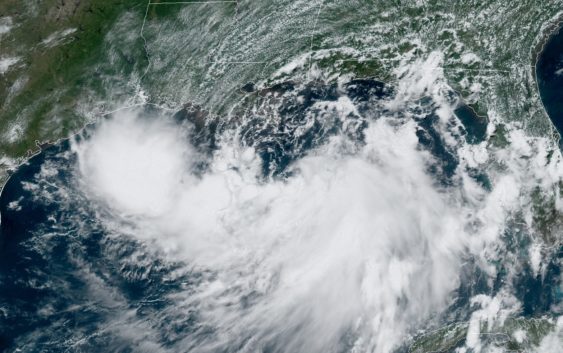
Tropical Storm Barry formed in the Gulf of Mexico on Thursday, and it could become a hurricane by late Friday, the National Hurricane Center says. Forecasters say the storm could bring a storm surge and heavy rains to Louisiana.
Barry is now predicted to become a Category 1 hurricane shortly before making landfall Saturday morning. Its maximum winds are expected to reach 75 mph — but officials are warning of perilous flash floods and other hazards.
“Water will be the biggest threat,” the National Weather Service office in New Orleans says. The agency has issued a flash flood warning for a wide area from Gulfport, Miss., to New Orleans and west of Baton Rouge. That warning is in effect through Sunday morning.
“There is a possibility that we’re going to get heavy rainfall for up to 48 hours,” New Orleans Mayor LaToya Cantrell said at a midday news conference Thursday.
“If you’ve not made a plan, you need to plan,” Cantrell said. She said the government doesn’t plan to issue any evacuation orders because of the timing of the storm’s arrival and its expected status as a Category 1.
“Sheltering in place is our strategy,” the mayor said. She then urged residents to secure their trash cans and not put them on sidewalks or streets.
“We cannot pump our way out” of some of the flooding, she added.
Forecasters say the tropical storm could bring a storm surge of 3-6 feet to a coastal area that is already struggling to cope with massive amounts of floodwaters from inland rains that have gorged the Mississippi River in recent weeks.
The tropical storm warning comes one day after New Orleans suffered “widespread street flooding and power outages” from strong storms, as member station WWNO reported.
Louisiana Gov. John Bel Edwards has declared a state of emergency for his entire state, warning: “No one should take this storm lightly. As we know all too well in Louisiana, low intensity does not necessarily mean low impact.”
Edwards says his office “is in constant communication” with the Federal Emergency Management Agency about the threat posed by the storm.
In Jefferson Parish, the sprawling region west of New Orleans that extends from Lake Pontchartrain down to the Gulf, residents of Grand Isle and other towns are coming under mandatory evacuation orders and curfews Thursday. To help keep the flow of traffic moving inland, officials suspended tolls shortly before those orders took effect.
Jefferson Parish residents are also being urged to make sure leaves and other debris are cleared away from storm drains and catch basins to help drain water from neighborhoods.
“It’s one little thing that everyone can do that makes a difference,” Councilwoman Jennifer Van Vrancken said during a news conference Thursday.
Local governments are rushing to give residents sandbags in many parts of Louisiana, including Baton Rouge and the northeast.
Barry is currently some 90 miles south of the Mississippi River’s mouth in Louisiana. On Thursday morning, its maximum winds were only 40 mph, but the storm is expected to strengthen as it creeps to the west and north.
Louisiana officials have already begun preparations. As member station WWNO reports, LSU is shutting down its campus on Friday and officials are telling residents along the coast to “heed every single warning” about what is expected to be a dangerous storm.
“Hurricane conditions are possible across the north-central Gulf Coast in a couple of days,” the National Hurricane Center says.
The center has issued three alerts for the expected storm:
- A storm surge warning from the mouth of the Atchafalaya River (some 60 miles south of Baton Rouge) to Shell Beach (20 miles southeast of New Orleans).
- A hurricane watch from the mouth of the Mississippi River to Cameron, La., near the Texas border.
- A tropical storm watch from the mouth of the Mississippi River northward to the mouth of the Pearl River.
In addition, the hurricane center says “a tornado or two are possible tonight and Friday across southern portions of Louisiana and Mississippi.”
Forecasters say the system likely will drop more than a foot of rain in some areas, predicting “accumulations of 10 to 15 inches near and inland of the central Gulf Coast through early next week, with isolated maximum rainfall amounts of 20 inches.”
The storm is moving at only 5 mph. Forecasters expect it to maintain a slow pace, producing a “long duration heavy rainfall threat long the central Gulf Cost and inland through the lower Mississippi Valley through the weekend and potentially into early next week.”
The last storm named Barry stalled out as a tropical storm at it made landfall in Mexico in 2013.
9(MDA3NzMxMTkxMDEzMDkyOTU3ODRmYjc2Mg001))