- Texas’ biggest wildfire started a year ago. How does the Panhandle look now?
- To her, Hurricane Helene debris isn’t trash. It is full of memories — and she’s returning them
- Bills introduced a year after state’s largest blaze seek to limit wildfires
- A year after Texas’ largest wildfire, Panhandle residents tugged between hope and anxiety
- Another $500M for Hurricane Helene relief in North Carolina passes key hurdle
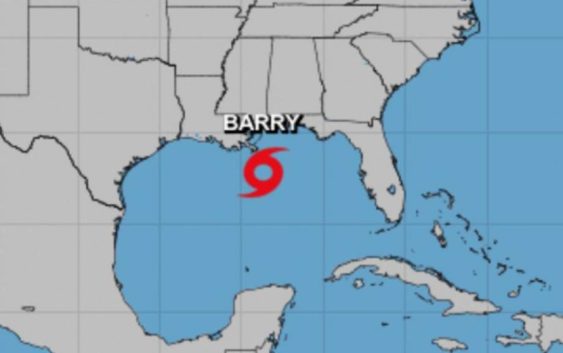
Tropical Storm Barry forms in Gulf of Mexico, threatening Louisiana but sparing Houston

-
Tropical Storm Barry forms in the Gulf of Mexico on Thursday, July 11, 2019, threatening Louisiana.
Tropical Storm Barry forms in the Gulf of Mexico on Thursday, July 11, 2019, threatening Louisiana.
Photo: National Hurricane Center
Tropical Storm Barry forms in the Gulf of Mexico on Thursday, July 11, 2019, threatening Louisiana.
Tropical Storm Barry forms in the Gulf of Mexico on Thursday, July 11, 2019, threatening Louisiana.
Photo: National Hurricane Center
Tropical Storm Barry has officially formed as a named storm in the Gulf of Mexico late Thursday morning, according to the National Hurricane Center.
The storm reached sustained wind speeds of at least 39 mph, the threshold for a tropical cyclone to become a named storm. Barry is expected to reach hurricane strength as it barrels for the Gulf coast.
Houston appears to be outside of Barry’s path, according to the National Weather Service, but that doesn’t mean it’s clear skies ahead.
There’s a 40 percent chance of showers and thunderstorms Thursday, mainly after 11 a.m. The high is expected to reach 97 with heat index values as high as 103.
The chance of rain drops to 30 percent Thursday night with a low around 80.
WATCH OUT: Worst Houston high water spots for road flooding
There’s a lingering possibility of rain in the forecast for Friday: 30 percent chance of showers and thunderstorms in the afternoon. The high will be near 95.
ON HOUSTONCHRONICLE.COM: Some Houstonians stock up as tropical system moves toward Gulf coast
New Orleans this morning is still under a flash-flood warning, which is expected to extend to Sunday.
The National Hurricane Center warns that the biggest threat this storm poses is continual rain: “The slow movement of this system will result in a long duration heavy rainfall threat along the central Gulf Coast and inland through the lower Mississippi Valley through the weekend and potentially into next week.”
There’s a possibility that the flooded Mississippi River could be lapping at the tops of levees this weekend.
Wednesday morning flooding affected downtown New Orleans. Residents could be seen kayaking in the streets as the storm stopped rush-hour traffic in that city.
STAY AHEAD OF BAD WEATHER: Text STORMS to 77453 to get breaking weather text alerts| Sign up to receive breaking news alerts delivered to your email here.