- Texas’ biggest wildfire started a year ago. How does the Panhandle look now?
- To her, Hurricane Helene debris isn’t trash. It is full of memories — and she’s returning them
- Bills introduced a year after state’s largest blaze seek to limit wildfires
- A year after Texas’ largest wildfire, Panhandle residents tugged between hope and anxiety
- Another $500M for Hurricane Helene relief in North Carolina passes key hurdle
Tropical Storm Barry Forecast to Hit Louisiana

HOUSTON — Barry became a tropical storm on Thursday morning with maximum sustained winds of 40 mph. The storm remains poorly organized and as of 7 pm the winds have only been able to increase to 45 mph.
This has allowed the NHC to lower its intensity forecast for the storm. We now expect Barry to make landfall on the Louisiana coast Saturday morning as a strong tropical storm with max winds near 70 mph.
TRACK BARRY: Barry interactive map, expected rainfall and more
LIVE BLOG: State of emergency in Louisiana with mandatory evacuations
HOUSTON FORECAST: Increasing rain chance Thursday and Friday
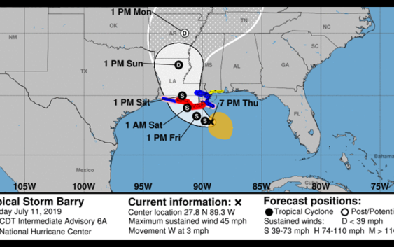
Below is the latest cone of uncertainty for Tropical Storm Barry, which shows the Texas coast is no longer in the forecast track. The updated cone shows Barry Making landfall around 7 a.m. Saturday along Louisiana.

NHC
7 PM Thursday Advisory:
A Hurricane Watch has been issued for nearly all of the Louisiana coastline, and a Tropical Storm Warning has been issued near New Orleans. Max sustained winds are 45 mph with the system moving west at 3 mph. At this time there are no watches or warnings along the Texas coast.
On this track, Houston can expect a few scattered thunderstorms, especially near the coast and Galveston bay, each morning and afternoon through the weekend.
Winds have already shifted to the northeast and this flow will continue through Saturday.
LINKS YOU CAN USE:
What do you need to do during a threat from the tropics?
- Make sure you check on the weather at least twice a day; once in the morning and once in the evening.
- Check your hurricane supply kits. Make sure you’re ready in the event we get a storm, which at this time remains very uncertain.
- Go over your storm plan with your family. Where would you go? What route would you take if asked to evacuate?
- Stay informed. Check in with us twice a day. Once in the morning and once before you go to bed so you don’t get caught off guard.
CLICK HERE FOR THE RED CROSS HURRICANE SAFETY CHECKLIST.
What are high pressure cells?
These are the steering currents that guide where a tropical storm or hurricane will make landfall.
Think of high pressure cells as bumpers. Hurricanes, as ferocious as they are, are lazy and don’t put up a fight with high pressure. They just go as they are told so-to-speak. As long as a high is over you, you’re good. The area of high pressure that was centered over us is backing westward and that will allow a small opening for a big moisture source.
For the latest updates on Tropical Storm Barry, click here or watch playlist below.